Volcanism on Venus
The planet may have had a major global resurfacing event about 500 million years ago,[1] from what scientists can tell from the density of impact craters on the surface.
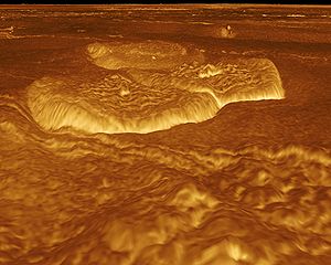
Radar sounding by the Magellan probe revealed evidence for comparatively recent volcanic activity at Venus's highest volcano Maat Mons, in the form of ash flows near the summit and on the northern flank.
Although many lines of evidence such as this suggest that volcanoes on Venus have been recently active, present-day eruptions at Maat Mons have not been confirmed.
They are usually associated with coronae and tesserae (large regions of highly deformed terrain, folded and fractured in two or three dimensions, which are unique to Venus).
On Venus, these volcanoes can cover hundreds of kilometres in area, but they are relatively flat, with an average height of 1.5 km (0.93 mi).
Large volcanoes cause the Venusian lithosphere to flex downward because of their enormous vertical loads, producing flexural moats or ring fractures around the edifices.
These dikes form a symmetrical network around the central point where the lava emerged, where there may also be a depression caused by the collapse of the magma chamber.
Arachnoids are so named because they resemble a spider's web, featuring several concentric ovals surrounded by a complex network of radial fractures similar to those of a nova.
Recent radar imagery shows more than 1,000 volcanic structures and evidence of possible periodic resurfacing of the planet by floods of lava.
In addition to the radar images, there is supporting evidence that volcanism has taken place, including an unusual change in the amount of sulphur dioxide gas in the upper atmosphere.
[10] In 2014, the first direct evidence for ongoing volcanism was located, in the form of infrared "flashes" over the edges of rift zone Ganis Chasma, near the shield volcano Sapas Mons.
These flashes were detectable during two or three consecutive Earth days in 2008 and 2009 and are thought to be caused either by hot gases or lava released from volcanic eruptions.
[12][13][14] In 2020, a study by University of Maryland supported by Swiss National Science Foundation and NASA discovered that 37 of Venus's coronae show signs of ongoing activity.
[15][16] In March 2023, at the 54th Lunar Planetary Science Conference, a team revealed the first images of volcanic activity on the surface of Venus.
The announcement consisted of two radar images from different cycles of Magellan data (8 months apart) that displayed a volcanic vent that had expanded by almost 2 square kilometers.
[19] No lightning has been directly observed, but the most compelling evidence is the very low frequency (VLF) radio emissions recorded beneath the clouds by all four of the Venera landers.
[23] The phosphines were detected at a height of 70 km, which implies a volcanic eruption on the explosive scale of Krakatau or Yellowstone on Earth.
[23][24] The implication of this is not only that Venus has experienced recent volcanism, but that it is capable of explosive eruptions despite the lack of hydrated melts similar to those created at subduction zones on Earth.
Both VERITAS and EnVision will use radar remote sensing to map the surface of Venus at resolution 10 times better than that of Magellan.
EnVision has the VenSAR (Venus Synthetic Aperture Radar) instrument that will map down to 30 m resolution and even down to 1 m in select areas.
[31] The SRS (Subsurface Radar Sounder) will penetrate the surface up to a kilometer and receive signals back that can be used to describe the internal structures of the planet.
[33] Some images created by this mapping can give a perspective view of the elevation of the surface of Venus, which assists in the identification of volcanoes.