Mapping of Venus
It involves surface radar images of Venus, construction of geological maps, and the identification of stratigraphic units, volumes of rock with a similar age.
Satellite radar provides imagery of the surface morphology by using the physical properties of wave reflection.
Long wavelength microwaves are used to penetrate the thick, cloudy atmosphere of Venus and reach to the surface.
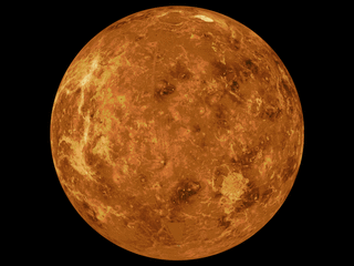
Before the development of radar-based observation, the thick yellow Venusian atmosphere hid surface features.
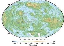
The global surface of Venus was first mapped by the Magellan orbiter during 1990–1991 with 50 km spatial and 100 m vertical resolution.
Cycle 3 (left looking) filled remaining gaps and collected stereo imagery of approximately 21.3% of the surface, increasing the total coverage to 98%.
[6] Instead of surface mapping by SAR as done by previous missions, InSAR would measure the terrain motions during events such as earthquakes or tectonic movements.
By performing the radar mapping at two separated times (before and after an event) over the same area, the terrain changes could be revealed.
If the surface being mapped is smooth, the incident radar pulse will be reflected away from the spacecraft, resulting in a weak echo, which is represented by darker regions SAR images.
On the other hand, if the surface is rougher, then more of the radar wave will be backscattered, and the intensity of echo will be stronger, which are represented by brighter areas in SAR images.
Despite the low resolution, it is useful to study the regional feature of Venus, including initial evidence for the existence of rift zones.
Here is a table comparing the different mapping scheme and unit identification by the Magellan science team (1994),[11] Vicki L. Hansen (2005)[12] and Mikhail A. Ivano and James W. Head (2011).
(defined by difference in radar backscatter, surface texture and topographic) (defined to global stratigraphy with a division of geologic time) (Further classification into 7 types, according to the features in Hansen and Willis' paper in 1996[14]) - Associated with impact events The details of the above mapping scheme and units will be discussed one by one below.
They traced and discussed the global spatial distribution of rock-stratigraphic units and structure, and suggested their time correlation and geological history.
[13] This mapping scheme suggests that there are approximately 12 global stratigraphic units on Venus which are present on different quadrangles.
Tesserae are regions of heavily deformed terrain, mostly located on highland areas (greater than 2 km in elevation) on Venus.
[23][24][25] However, there are some tessera-like deformations additional to the ridge belts, it suggests there are some possible overlapping of formation time in unit t and pr.
Ridges planes have older ages compared to surrounding regional plains (pr) due to the difference in radar albedo and embayment relationships suggested by McGill and Campbell (2006).
[26] The major occurrence of this unit is located among Vinmara, Atalanta, Ganiki, and Vellamo Planitiae, shich in a broad fan-shape,[27][28][29][30] and also appears between Ovda and Thetis Regiones and in the southern hemisphere within Lavinia Planitis.
[13] When looking at the cross-cutting relationship, the inner ridges of the belts seems to be embayed by the material of regional plains (pr), which covered the plateau surface.
[13] Regional plains are divided into abundant lower unit (rp1, Rusalka Formation) with smooth surface and relatively low radar backscatter and upper unit (rp2, Ituana Formation) with also smooth surface, but higher radar albedo.
Based on the analysis by Crumpler and Aubele (2000),[46] 10% of this unit shows evidence that it is younger than regional plains (rp).
[48][49] (3) small ps units are inside the tessera regions (such as Ovda Regio), which may associate with a volcanic origin, Due to the usual higher elevation of smooth plains, it is possible that the volcanic material of smooth plains is a younger unit.
[13] The Lobate plains unit (pl) is a smooth surface crossed with some extension features associated with rift zones.
[13] One possible origin of this unit is from massive and multiple eruptions from large and localized volcanoes with little later extensional deformation.
[13] The Rift zones unit (rz) belongs to the Devana Formation, which is also made up of dense extensional structures with defined numbers of fissures and troughs containing flat-floors.
In testing the model of catastrophic and equilibrium Model (another hypothesis other than global stratigraphy[52]) on Venus, it is found that the older regional plains (rp) are embaying only around 3% of the impact craters and the younger lobate plains (pl) are embaying around 33% of the impact crater on Venus.
[53] Under the Global stratigraphic Classification Scheme, by correlating the units mentioned above (Mikhail A. Ivano and James W. Head, 2011),[13] the researchers suggested three phases of Venusian geological history: (1) The earliest period, Fortunian Period, involved intensive formation of tessera (t) (building of thick crust at the same time).
The mapping scheme applied by Vicki L. Hansen is mainly regional based, instead of using global stratigraphy as Mikhail A. Ivano and James W. Head did.
For the term "complex ridged terrain (CRT)" used by the Magellan science team (1994),[11] it carries confusions.