Way of the Patriarchs
[citation needed] The modern Highway 60 follows roughly the route of the Way of the Patriarchs[2][3] (without the more recent bypasses), passing through Afula, Jenin, Nablus, Ramallah, Jerusalem, Bethlehem, Halhul, Hebron and Dhahiriya.
Way stations were discovered along the route between Beersheba and Jerusalem from the time of the ancient Temple[dubious – discuss] and later during the Hellenistic and Roman eras.
[10] The Way of the Patriarchs passes by Khirbet Beit Zakariyyah, a small Palestinian village near the Israeli settlement of Alon Shevut, possibly the site of the Battle of Beth Zechariah between Judas Maccabeus and the Seleucid Greeks.
The route from Bethel southwards would have passed through today's neighborhoods of Beit Hanina, Shuafat, French Hill, Givat HaMivtar and Kerem Avraham, crossing Jaffa Road at the center of modern down-town Jerusalem behind the HaMashbir Department Store building, and continuing along Shmuel HaNagid St. (peak height: Ratisbonne Monastery), King George St., Keren HaYesod St., and finally the Hebron Road to Bethlehem.
[citation needed] The route connected to Via Maris and the King's Highway by way of several east-west roads: An important connection was "The Sunset Road" (Hebrew: דֶּרֶךְ מְבוֹא הַשֶּמֶש Derech Mevo HaShemesh) (Deut 11:29–30) leading from The King's Highway, crossing the Jordan River at the location of today's Adam Bridge (Jisr Damiat) and ascending through the Tirtza Valley (Wadi Al Fara) to Mount Gerizim and Shechem.
[citation needed] "The Bethoron Ascent" (Hebrew: מַעֲלֵה בֵּית חוֹרוֹן Ma'ale Beit Horon) (Josh 10:10) from the coastal plain passes today's Ben Gurion Airport, then rose along an offshoot of the watershed ridge leading to today's Beit Hanina as it approached Jerusalem.


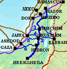
1–Sunset Road
2–Red Ascent
3–Aphek Ascent
4–Beit Horon Ascent
5–Ayalon Road
6–Lachish Road