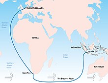
Brouwer Route
Thus it took advantage of the strong westerly winds for which the Roaring Forties are named, greatly increasing travel speed.
[1] The problem with the route was lack of an accurate way, at the time, to determine longitude,[2] and thereby to know how far east a vessel had travelled.
Consequently, many ships were damaged by or wrecked on rocks, reefs, or islands on the western continental shelf of Australia, which was virtually unknown to Europeans at the time.
The route was devised by the Dutch explorer Hendrik Brouwer in 1611, and found to halve the duration of the journey from Europe to Java, compared to the previous Arab and Portuguese monsoon route, which involved following the coast of East Africa northwards, sailing through the Mozambique Channel round Madagascar and then across the Indian Ocean, sometimes via India.
By 1616 the Brouwer Route was compulsory for ship captains of the Dutch East India Company headed to Java.