West Sacramento, California
In 1844, John Schwartz, a Flemish traveler, was the first Euro-American to permanently settle in the area of West Sacramento, which at that time was part of Mexico.
In addition to the fishery, they also found the soil to be fertile and began farming and raising livestock.
The announcement of the discovery of gold at Sutter's Mill in 1848 brought a multitude of miners to the region.
In 1846, a man named James McDowell bought 600 acres (240 ha) from John Schwartz.
The McDowell family experienced first-hand the violence that the gold rush era brought with it.
In October 1849, Margaret hired a land surveyor to map out 160 acres (65 ha), which was then divided into forty one blocks.
During its first ten years, the rural Town of Washington went through a significant increase in business development and shipping activity.
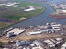
One of the first businesses to be established in the town was the California Steam Navigation Company, which was attracted to the area in 1859 by how close the Sacramento River is to it.
Other businesses in early Washington included hotels, saloons, and restaurants catering to the needs of people passing through.
Many of the travelers making the treacherous journey through the marshlands on their way to Sacramento were appreciative of the rest stop at the Town of Washington.
Salmon, sturgeon, catfish, eel, crayfish, and clams proved to be lucrative in this region as fisherman soon found.
The river settlement was flourishing, stocking fish markets not only in Sacramento, but in San Francisco as well.
In addition, the rich soil of the valley produced abundant crops of corn, melons, cucumbers, and sweet potatoes.
When the California Steam Navigation Company came to Washington, Bryte used the steamships to carry his dairy products to various markets within the region.
Bryte was able to own several thousand acres of land in the area to farm on, as well as raise his many livestock on.
Mike Bryte's influence in the community was marked by his election to the Yolo County Board of Supervisors and later as sheriff.
West Sacramento, incorporated in 1987, consists of three communities that were originally distinct towns, Broderick, Bryte, and West Sacramento (originally just the community north of the port canal and south of the railroads), as well as the Southport area.
Southport, which comprises about half of the city's land area, originally consisted of rural homesteads and small neighborhoods in Arlington Oaks and Linden, but now has a considerable population that resulted from housing booms in the early 1990s and the early 2000s, adding new neighborhoods in Bridgeway, Gateway, River Ranch, and Newport.
[18] West Sacramento is the home of the California Highway Patrol Academy,[19] and the CHP Museum is housed on the same grounds.
[42] Raley's, a major grocery store chain in Northern and Central California, has its corporate headquarters in West Sacramento.
The California State Teachers Retirement System pension fund CalSTRS is based in West Sacramento and its headquarters tower on the riverfront is the city's tallest building.
[48] The service, called West Sacramento On-Demand, offers trips anywhere in the city for a flat fare.