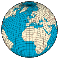
Longitude
Longitude (/ˈlɒndʒɪtjuːd/, AU and UK also /ˈlɒŋɡɪ-/)[1][2] is a geographic coordinate that specifies the east-west position of a point on the surface of the Earth, or another celestial body.
The principle is straightforward, but in practice finding a reliable method of determining longitude took centuries and required the effort of some of the greatest scientific minds.
[3]: 11 [4] Claudius Ptolemy (2nd century CE) developed a mapping system using curved parallels that reduced distortion.
[8]: 65 Hindu and Muslim astronomers continued to develop these ideas, adding many new locations and often improving on Ptolemy's data.
[9][10] For example, al-Battānī used simultaneous observations of two lunar eclipses to determine the difference in longitude between Antakya and Raqqa with an error of less than 1°.
This is considered to be the best that can be achieved with the methods then available: observation of the eclipse with the naked eye, and determination of local time using an astrolabe to measure the altitude of a suitable "clock star".
[11][12] In the later Middle Ages, interest in geography revived in the west, as travel increased, and Arab scholarship began to be known through contact with Spain and North Africa.
[20] On land, the period from the development of telescopes and pendulum clocks until the mid-18th century saw a steady increase in the number of places whose longitude had been determined with reasonable accuracy, often with errors of less than a degree, and nearly always within 2° to 3°.
In response to the problems of navigation, a number of European maritime powers offered prizes for a method to determine longitude at sea.
[25] Chronometers had the advantages that both the observations and the calculations were simpler, and as they became cheaper in the early 19th century they started to replace lunars, which were seldom used after 1850.
The Survey established chains of mapped locations through Central and South America, and the West Indies, and as far as Japan and China in the years 1874–90.
[30] Wireless time signals for the use of ships were transmitted from Halifax, Nova Scotia, starting in 1907[31] and from the Eiffel Tower in Paris from 1910.
[34] They allowed accurate navigation when poor visibility prevented astronomical observations, and became the established method for commercial shipping until replaced by GPS in the early 1990s.
Longitude, being up to 180° east or west of a prime meridian, is mathematically related to time differences up to 12 hours by a factor of 15.
The Greek letter λ (lambda)[38][39] is used to denote the location of a place on Earth east or west of the Prime Meridian.
The international standard convention (ISO 6709)—that east is positive—is consistent with a right-handed Cartesian coordinate system, with the North Pole up.
Confusingly, the convention of negative for east is also sometimes seen, most commonly in the United States; the Earth System Research Laboratories used it on an older version of one of their pages, in order "to make coordinate entry less awkward" for applications confined to the Western Hemisphere.
An example is a calculation of east displacement by subtracting two longitudes, which gives the wrong answer if the two positions are on either side of this meridian.
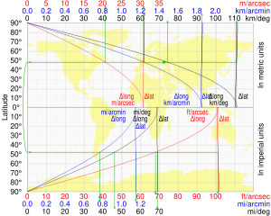
For a sphere of radius a that radius at latitude φ is a cos φ, and the length of a one-degree (or π/180 radian) arc along a circle of latitude is When the Earth is modelled by an ellipsoid this arc length becomes[41][42] where e, the eccentricity of the ellipsoid, is related to the major and minor axes (the equatorial and polar radii respectively) by An alternative formula is cos φ decreases from 1 at the equator to 0 at the poles, which measures how circles of latitude shrink from the equator to a point at the pole, so the length of a degree of longitude decreases likewise.