2014–15 North American winter
Temperatures in much of the United States dropped 15 to 35 °F (8.3 to 19 °C) below average by November 19, following a southward "dip" of the polar vortex into the eastern two-thirds of the country.
[2] In addition, significant winter weather occurred throughout the season, including a major blizzard that struck the Northeastern United States at the end of January, another blizzard that affected much of the Northern United States days later in early February, and several significant snow events paired with very frigid temperatures for much of February.
Many records for snowfall and temperature were broken, many for the month of February, with every state east of the Mississippi River being colder than average, some for the entire winter.
Above-average conditions were also expected to pervade the winter months in the western U.S., the Intermountain West extending across the U.S.–Canada border through New York and New England, and Alaska and Hawaii.
First, a cyclone in the Bering Sea enabled a change in the atmospheric pattern to occur; according to Jeff Masters from Weather Underground, this cyclone brought about a "ripple" in the jet stream, and the presence of a high-pressure ridge over the western United States and a low-pressure trough over the southern and central United States enabled a great intrusion of very cold air to pervade southward out of Canada.
[11] Due to the storm, over 4,500 flights were canceled and over 400,000 people were without power on November 27; southern New Hampshire was the worst hit, experiencing up to 200,000 outages.
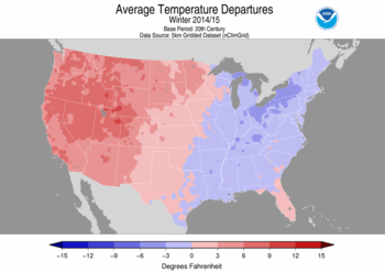
[17] Due to a persistent stationary high-pressure pattern over the west coast that redirects the jet stream, it remained (and remains) in a wavy ideal configuration to bring warm air north over the western U.S. and cold air towards the south over the continental states, and to favor winter storms over the East Coast.
In contrast, in the West a persistently strong ridge of high pressure over the warm eastern Pacific Ocean and western North America elevated temperatures to record levels from Arizona to Washington.
[24] Michigan received snow totals as high as 36.1 inches (92 cm) through December 12 from a system associated with the early cold wave.
[11] On December 9, a strong nor'easter moved ashore over New England, bringing with it heavy rain, wind, some ice, and snow[28] in interior parts of the region, some which were battered hard by Hurricane Sandy more than 2 years prior.
On hillsides scorched by wildfires, the rains brought down mud and rocks which covered part of California State Route 91.
An area of low pressure formed along this front, and was originally weak at first and produced moderate to heavy snowfall in the Northwest through December 28.
As it approached the Southwest early on December 29, the low intensified somewhat as it neared the subtropical branch of the jet steam, and slowly began to draw moisture from the Pacific Ocean and the western half of the Gulf of Mexico.
On January 3, the winter storm began to develop thunderstorms along its cold front as it tracked into the Deep South, which was also a threat for tornadoes.
On January 1, 2015, Los Angeles experienced a record low of 36 °F (2 °C), a temperature matched in Pasadena, where the Tournament of Roses Parade was not the coldest in history as forecasters had expected.
The storm system quickly moved southeastward into the Upper Midwest during the evening of January 24, taking a path typical of an Alberta clipper.
[43] By noon on January 25, the upper-level low was centered near the border between Iowa and Missouri in correlation with a weak shortwave trough.
[49] Early on January 30, the nor'easter left the East Coast, even as another winter storm began to impact the region.
[50] A major winter storm occurred from January 31 – February 2, bringing blizzard conditions to the Chicago area with 19.3 inches (49 cm) of snow, being the fifth-largest snowfall in city history.
Governor of Massachusetts Charlie Baker declared a state of emergency, and MBTA subway and commuter rail trains were suspended on February 10.
[56] Well below normal temperatures covered a large portion of the eastern United States and were expected to stay in place, with only slight moderation, through the rest of the month.
Originally composed of all rain, snow began to break out on the northern side of the winter storm due to cold air beginning to penetrate into the Deep South.
[64] The winter storm also produced a small but potent line of thunderstorms in the Florida Peninsula, as such a tornado watch was issued.
The third in the series of winter storms happened from February 28 into late March 1, and spread a swath of snow and ice from the High Plains to New England.
[67] The system organized from an upper-level impulse associated with a developing southward dip in the jet stream, which led to the formation of a weak area of low pressure.
[68] The fourth and final winter storm came right on the heels of the previous system, and actually occurred in two phases, with the latter bringing record cold in its wake.
[72] According to the National Oceanic and Atmospheric Administration, from February 1 to 28, 2015, 898 lowest minimum temperature records were broken and 91 were tied in the Northeastern United States.
Snowflakes fell on 19 out of 28 days in the Boston, Massachusetts area, setting records in numerous locations with depths up to over 36.0 inches (91 cm) deep in certain places.
The greatest departures from normal occurred in the vicinity of southern Idaho, where temperatures in Pocatello averaged 32.2 °F (0.1 °C), the seventh-warmest December in the area's 72-year record.
California also experienced its fourth-driest January on record, receiving only 15 percent of its average precipitation for what would ordinarily be the wettest month of the year.