Wrexham County Borough
The north of the county borough is relatively urbanised and centred on Wrexham, with a population of 44,785, its industrial estate and several outlying villages, such as Brynteg and Gwersyllt.
Further south again is the town of Chirk, near the border with Shropshire, while the Ceiriog Valley to the south-east and English Maelor to the south-west of the county borough are rural.
The Dee itself enters the county borough near Cefn Mawr and flows east and then north-east toward Cheshire, creating a wide plain.
The north-west of the county borough, down to Chirk, is part of the Clwydian Range and Dee Valley AONB, and includes the Ruabon Moors uplands.
The county borough has a strong industrial history; a notable early business is Bersham Ironworks, in the Clywedog Valley, which operated between 1715 and 1812 and pioneered cannon manufacture.
The Pontcysyllte Aqueduct near Cefn Mawr is an important surviving piece of early industrial infrastructure and has been designated a UNESCO World Heritage Site.
The contemporary economy of the county borough has diversified into industries such as engineering, pharmaceuticals, electronics, and food processing, with agriculture dominant in the south-east and south-west.
[26] The Fenn's, Whixall and Bettisfield Mosses National Nature Reserve is located in the south-east of the county borough along the Wrexham-Shropshire border.
The most recent Wrexham County Borough election on 5 May 2022,[57] resulted in independent politicians maintaining their position as the largest group with 23 members but falling short of a majority, leaving the council in no overall control.
[74] In the 2019 United Kingdom general election, Conservative candidates won the constituencies of Wrexham and Clwyd South for the first time in their existence.
[88] In March 2024, The Municipal Journal, stated that an investigation had begun into an allegation of malfeasance in office by Wrexham councillors, with both North Wales Police and the Welsh Government participating in the case.
[95][97] The brewery produced the first German-brewed lager in the United Kingdom, and was located in Wrexham for the brewing quality of its underground spring water.
The brewery can be traced back to a minor brewing business operating out of the Nag's Head Public House on Tuttle Street.
In the 19th century this clay was the centrepiece for Ruabon's tile and terracotta production on a vast scale, leading the village to be nicknamed "Terracottapolis".
[139][140] Notable stadia in the county borough include the Racecourse Ground, the oldest in Wales; The Rock; and an athletics stadium at Queensway.
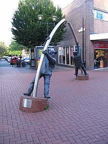
In 1950, Wrexham (specifically Plas Coch) was a stop in the world's first scheduled helicopter passenger service between Liverpool and Cardiff by British European Airways.
[157] The route was 4.4 miles (7.1 km) long, connecting the mining villages with Wrexham city centre and General railway station.
The county borough is ranked thirteenth in population growth among principal areas, with both Denbighshire (2.2%) and Flintshire (1.6%) growing faster, although Powys also increased by 0.2%, and Conwy (also in ceremonial Clwyd) shrunk by 0.4%.
[173] The county borough is twelfth in population density of the principal areas of Wales, with 268 people per square kilometre, more than the national average of 150.
[182] The highest proportion of Welsh-language speakers in the county borough is in the rural Ceiriog Valley ward, where 31.2% can speak the Welsh language.
[28] In 2019, secondary schools in Wrexham were criticised by Estyn, the Welsh education and training inspectorate, for having the poorest attendance of the principal areas in Wales.
[213] Notable buildings and structures such as St Giles' Church, Chirk Castle and Pontcysyllte Aqueduct also act as symbols for the county borough.
[223][224] It was built between 1283 and 1311 by Earls of Surrey, John de Warenne and his grandson, following Llywelyn ap Gruffudd, the Prince of Wales' defeat.
[230]The most notable country estate is at Erddig Hall, a Grade-I listed National Trust property, located to the south of Wrexham.
Notably the home of the Williams-Wynn family, the Wynnstay Hall stands above the River Dee overlooking the Vale of Llangollen and Y Berwyn.
Its No.2 shaft headgear with its colliery wheel and an engine house with an electric winding gear, as well as other buildings remain standing as part of a small industrial estate.
[239] In 1763 it was passed to John "Iron Mad" Wilkinson, who developed a new method of gun manufacture with Francis Bacon, where the cannons were first cast solid then bored out afterwards.
The site has since been converted into a country park, covering 53 acres (0.21 km2) of grassland, woodland and the former lead mines, it also hosts a tourist centre.
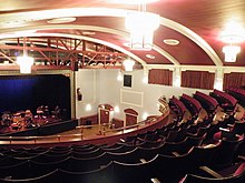
[272] The 890-seat William Aston Hall in Wrexham University, and the 150-seat Studio Theatre in Coleg Cambria Yale also acts as a venue for events.
Located in Wrexham city centre on Regent Street,[273] it is housed in County Buildings which was built in 1857 as a military barracks,[49][274] later becoming a police station and Magistrates' court in 1879,[49][274][275] until it opened as a museum in 1996 and refurbished in 2010–11.