Yukon River
The longest river in Alaska and Yukon, it was one of the principal means of transportation during the 1896–1903 Klondike Gold Rush.
[20][failed verification][citation needed] However, the Environmental Protection Agency does not list the Yukon River among its impaired watersheds, and water-quality data from the U.S. Geological Survey shows relatively good levels of turbidity, metals, and dissolved oxygen.
[23] White water river in fact corresponds to Gwich'in words that can be shortened to form Yukon.
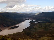
The generally accepted source of the Yukon River is the Llewellyn Glacier at the southern end of Atlin Lake in British Columbia.
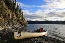
North of Whitehorse, the Yukon River widens into Lake Laberge, made famous by Robert W. Service's "The Cremation of Sam McGee".
There are a number of communities after the "head of passes," as the channel division is called locally: Nunum Iqua, Alakanuk, Emmonak, and Kotlik.
The construction of the dam flooded the White Horse Rapids, which gave the city its name, and created Schwatka Lake.
[31] This locale near the Seward Peninsula represents the near westernmost limit of the Black Spruce, Picea mariana,[32] one of the most widespread conifers in northern North America.
Each year Chinook, coho, and chum salmon return to their terminal streams in Alaska, the Yukon Territory, and British Columbia.
The Chinook, which arrive at the mouth of the Yukon River in early June, have the longest journey – as many as 2,000 miles against the current, with an estimated 35–50% bound for Canada.
[citation needed] The root cause of these poor returns remains debated, with questions about the effects of climate change on ocean food-supply & disease prevalence in returning adults, the methods of fishing used on the river, and the effects of the Bering Sea Pollock trawl fleet on food supply and salmon bycatch.
[39][40] In 2010, the Alaska Department of Fish & Game's Board of Fisheries issued the first-ever restriction for net mesh size on the Yukon, reducing it to 7.5 inches (190 mm).
Its organizational goals include giving voice to the village fishers that have traditionally managed these resources, enabling communication between fishers and fishery managers, and helping to preserve the ecological integrity of salmon runs and local cultures' Traditional Ecological Knowledge[43] In March 2001, the U.S. & Canadian governments passed the Yukon River Salmon Agreement to better manage an internationally shared resource and ensure that more Canadian-originated salmon return across the border.
[45] Tribal organizations such as the Association of Village Council Presidents (AVCP), Council of Athabascan Tribal Governments (CATG), and Tanana Chiefs Conference (TCC) work to sustain Yukon River salmon to promote healthy people, cultures, and communities.