Zanclean flood
Based on the erosion features preserved until modern times under the Pliocene sediment, Garcia-Castellanos et al. estimate that water rushed down a drop of more than 1,000 metres (3,300 ft) with a maximum discharge of about 100 million cubic metres per second (3.5 billion cubic feet per second), about 1,000 times that of the present-day Amazon River.
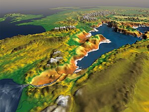
Studies of the underground structures at the Strait of Gibraltar show that the flooding channel descended gradually toward the bottom of the basin rather than forming a steep waterfall.
[6] This triggered the Messinian Salinity Crisis with the formation of thick salt deposits on the former seafloor[7] and erosion of the continental slopes.
[6] Already before the Zanclean flood, increased precipitation and runoff had lowered the salinity of the remnant sea,[7] leading to the deposition of the so-called "Lago Mare" sediments,[12] with some water putatively originating in the Paratethys north of the Mediterranean.
[20] The formation of the channel mobilized about 1,000 cubic kilometres (240 cu mi) of rock,[21] which was deposited in the Alboran Sea in the form of giant submarine bars.
[10] Whether the Zanclean flood occurred gradually or as a catastrophic event is controversial,[23] but it was instantaneous by geological standards.
[29] The flood affected only the Western Mediterranean at first, because the Sicily Sill (located at the present Straits of Sicily) formed a barrier separating its basin from the Eastern Mediterranean basin[30] that probably overflowed through the Noto Canyon across the Malta Escarpment;[31] in addition a sill may have existed in the eastern Alboran Sea at this time.
[32] During the flooding across the Noto Canyon, vortices and reverse flows occurred,[33] and large amounts of sediments were emplaced in the Ionian Sea.
[39] The absence of a catastrophic flooding event is supported by geological evidence found along the southern margin of the Alboran Sea.
[40] On the other hand, deposits found around the Malta Escarpment imply that one intense flood led to the reconnection across the Straits of Sicily.
[51] Rising sea levels made the deeply incised Nile river become a ria as far inland as Aswan, some 900 km (560 mi) upstream from the modern coast.
[65] In his book Historia Naturalis, Pliny the Elder mentions a legend that Hercules dug the Strait of Gibraltar between the Mediterranean and the Atlantic Ocean, connecting the two.
[66] The actual Zanclean flood theory however only arose during the 1970s, when it became clear that salt deposits and a widespread erosion surface in the Mediterranean had been emplaced during a prolonged sea level lowstand, and that the subsequent reflooding took place in only a few millennia or less.