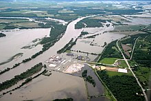
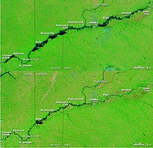
2011 Missouri River Flood
According to the National Weather Service, in the second half of the month of May 2011, almost a year's worth of rain fell over the upper Missouri River basin.
Extremely heavy rainfall in conjunction with an estimated 212 percent of normal snowpack in the Rocky Mountains contributed to this flooding event.
[5] Officials said that problems downstream could have been alleviated by river control work and new levee construction that came about in the wake of the Great Flood of 1993.
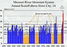
[3][4] A study by Utah State University[6] examined the buildup of water storage leading to the 2011 Missouri River flooding[7] observed by GRACE satellites indicated that precipitation over the MRB undergoes a profound modulation during the transition points of the Pacific quasi-decadal oscillation and associated teleconnections.
The results infer a prominent teleconnection forcing in driving the wet/dry spells in the MRB, and this connection implies persistence of dry conditions for the next 2 to 3 years, which is linked to the 2012–2013 Midwestern drought.
[14] During the flood, every bridge between Omaha and Kansas City was either closed entirely, had exit ramps blocked or had other work at some point.
On May 22, 2011, flooding of the Little Bighorn River and nearby tributaries inundated Crow Agency and shut down Interstate 90 between Hardin and the Wyoming state line.
[26] Flooding on Pryor Creek, another tributary of the Yellowstone River prompted closing of Pompeys Pillar National Monument.
[25][27] On May 10 President Barack Obama declared much of North Dakota a disaster area over flooding which began on February 14 and had been continuing.
[30] On June 21, 12,000 people, a quarter of the town's population, were ordered to evacuate after Lake Darling Dam had to step up its release of water.
After the first partial collapse, the Corps of Engineers initiated an emergency contract to raise the levee immediately surrounding the town in order to protect it from an estimated 10 feet (3.0 m) of flood water.
[41] On June 25, a levee breach north of Council Bluffs flooded an area of Harrison County which could impact U.S. Route 30 connecting Blair, Nebraska and Missouri Valley, Iowa.
They had raised the levee height in anticipation of the flood but after the upstream breach they had sought permission to lower it so that water could flow back into the river.
[52] On June 9, Nebraska reported its first event-related fatality when a worker was killed while working on a levee at Fort Calhoun when his truck tipped over.
[55] On June 7, a fire broke out in the plant's switch gear room, prompting the Nuclear Regulatory Commission to declare an "Alert", which is level 2 on the NRC's emergency classification.
[56][57] Officials for the plant's owner, the Omaha Public Power District (OPPD), were confident that enough redundancies were in place to ensure adequate safety.
[59] On June 23 a helicopter being used by OPPD to survey transmission lines made an unplanned landing 1.5 miles (2.4 km) south of the plant.
[60] On June 26 the 2,000 feet (610 m) long rubber berm at the plant collapsed after it was punctured by a small earth mover ("Bobcat").
Similar to the situation at Fort Calhoun, the FAA placed a temporary no-fly zone within 2 miles (3.2 km) of the plant on June 7.
In preparation for the flood more than 5,000 short tons (4,500,000 kg) of sand were bought in for barricades and Hesco barriers protecting facilities at the plant.
[69] On June 23, the main levee 3 miles (4.8 km) north of Brownville bridge breached, prompting an evacuation in Atchison County, MO.
[74] On July 5, the National Geospatial-Intelligence Agency reported that 265 square miles (690 km2) of Nebraska has been inundated by floods on the Missouri and the Platte River.
The letters arrived just as the floods began hitting their peak in Atchison County and subsequently were heavily criticized by state and federal politicians.
[89] On June 26 BNSF had to close its main rail line providing coal to Kansas City's Iatan Powerplant (via Rulo) after the river widened in Holt County to nearly 5+ miles by Big Lake.
"[93] On June 28, the Corps ordered Ameren to halt all outflows (including electrical generation) from Bagnell Dam on the Osage River until at least July 5.
[95][96] On June 30 the St. Joseph News-Press reported that residents of Holt County had dubbed the flood "Corpstrina" (pronounced Kor-TRINA) evoking the Corps of Engineers which regulates the river and the Hurricane Katrina disaster.
[97] On July 2 Amtrak announced that two miles (3 km) of track between Kansas City and St. Louis was flooded between Myrick (west of Lexington) and Marshall.
[99] On July 4 St. Charles held its Riverfront fireworks display on the river—although moved back a block to Riverside Drive from Frontier Park.
[107] On Jun 29 the Elwood, Kansas, south bound exit ramp off the Pony Express Bridge was closed temporarily to pump water which had accumulated from rains.
However, on June 29 photos began circulating that the low-lying Atchison Union Pacific rail bridge was close to water level.