49th parallel north
However, it is often difficult to precisely determine the location of a watershed in a region of level plains, such as in central North America.
This treaty established the boundary only between the line of longitude of the northwesternmost point of Lake of the Woods, on the east, and the Rocky Mountains, on the west.
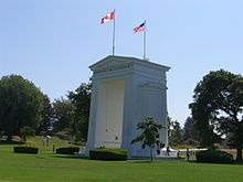
Among these peoples, the 49th parallel was nicknamed the Medicine Line because of its seemingly magical ability to prevent U.S. soldiers from crossing it.
[5] In the 1844 U.S. presidential election, the Democratic Party asserted that the northern border of the Oregon Territory should be 54°40′, later reflected in the 1846 slogan "Fifty-Four Forty or Fight!"
Three provinces, New Brunswick, Prince Edward Island, and Nova Scotia, are each entirely south of the parallel, but the vast majority of Canadian territory lies north of it.
Parts of the 49th parallel were originally surveyed using astronomical techniques that did not take into account slight departures of the Earth's shape from a simple ellipsoid, or the deflection of the plumb-bob by differences in terrestrial mass.
The Digital Chart of the World (DCW), which uses the Clarke 1866 ellipsoid, reports the border on average at latitude 48° 59′ 51″ north, roughly 270 metres (886 ft) south of the modern 49th parallel.
At the time that the United States and Great Britain agreed on the 49th parallel as the boundary, much of the North American continent had not yet been mapped.
After the boundary was established, British surveyors discovered that Point Roberts lay south of the 49th parallel.