Alberta clipper
They are associated with cold, dry continental air masses and generate small-scale, short-lived weather events typically producing 8–15 cm (3.1–5.9 in) of snow in a 3-6 hour period.
However, they can precipitate sudden temperature drops and sharp winds leading to local blizzard conditions, especially when interacting with moisture from the Great Lakes.
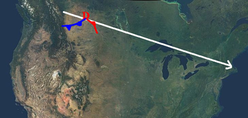
[3][6] The term was coined in the late 1960s by Rheinhart Harms, a meteorologist at the U.S. National Weather Service Office in Milwaukee, Wisconsin, who noted the rapid speed of these snow-producing storms as they moved across the Dakotas from Alberta towards the Great Lakes.
[3][10][11][12] A clipper originates when warm, moist winds from the Pacific Ocean come into contact with the mountains in the provinces of British Columbia and then Alberta.
The storm then moves east-southeast riding the jet stream, and passes off the upper Atlantic Coast, normally north of Delaware Bay.