Analemma
In astronomy, an analemma (/ˌænəˈlɛmə/; from Ancient Greek ἀνάλημμα (analēmma) 'support')[a] is a diagram showing the position of the Sun in the sky as seen from a fixed location on Earth at the same mean solar time over the course of a year.
The change of position is a result of the shifting of the angle in the sky of the path that the Sun takes in respect to the stars (the ecliptic).
The east–west component results from the nonuniform rate of change of the Sun's right ascension, governed by the combined effects of Earth's axial tilt and its orbital eccentricity.
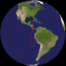
This curve is commonly printed on terrestrial globes, usually in the eastern Pacific Ocean, the only large tropical region with very little land.
It is possible, though challenging, to photograph the analemma, by leaving the camera in a fixed position for an entire year and snapping images on 24-hour intervals (or some multiple thereof); see section below.
The long axis of the figure—the line segment joining the northernmost point on the analemma to the southernmost—is bisected by the celestial equator, to which it is approximately perpendicular, and has a "length" of twice the obliquity of the ecliptic, i.e., about 47°.
Viewed from an object with a perfectly circular orbit and no axial tilt, the Sun would always appear at the same point in the sky at the same time of day throughout the year and the analemma would be a dot.
For an object with a circular orbit but significant axial tilt, the analemma would be a figure of eight with northern and southern lobes equal in size.
In many diagrams of the analemma, a third dimension, that of time, is also included, shown by marks that represent the position of the Sun at various, fairly closely spaced, dates throughout the year.
In practice, the analemma is so nearly symmetrical that the shapes of the mirror images are not easily distinguished, but if date markings are present, they go in opposite directions.
[2] The book "Analemma" (Greek: Περὶ ἀναλήμματος) by Ptolemy deals with the means for plotting the celestial coordinates of the Sun or any other heavenly body for any geographical latitude at any time.
[5] Analemmas (in the modern sense of the term) have been used in conjunction with sundials since the 18th century to convert between apparent and mean solar time.
Before this, the term had a more generic meaning that referred to a graphical procedure of representing three-dimensional objects in two dimensions, now known as orthographic projection.
[8] In 1812, John Lathrop wrote:[9] What is called the analemma, on the globe, is a narrow slip of paper, the length of which is equal to the breadth of the torrid zone.
The analemma is plotted with its width highly exaggerated, revealing a slight asymmetry (due to the two-week misalignment between the apsides of the Earth's orbit and its solstices).
If viewed at the analemma in the early morning or evening, it would start to tilt to one side as the viewer moves southward from the North Pole.
Crossing the Antarctic Circle the analemma, now nearly completely inverted, would start to disappear, until only 50%, part of the larger loop, was visible from the South Pole.
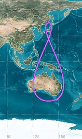
The adjacent figure ("Analemma: Equation of time...") is calculated using the algorithm presented in the reference[12] that uses the formulas given in The Astronomical Almanac for the Year 2019.
A date-marked diagram of the analemma, with equal scales in both north–south and east–west directions, can be used as a tool to estimate quantities such as the times of sunrise and sunset, which depend on the Sun's position.
Some approximations are involved in the process, chiefly the use of a plane diagram to represent positions on the celestial sphere, and the use of drawing and measurement instead of numerical calculation.
Similarly, when the Sun is at the highest point on the analemma, near its top-left end, (on 15 June) the earliest sunrise of the year will occur.
The measurement should, of course, be done on the diagram, but it should be expressed in terms of the angle that would be subtended at an observer on the ground by the corresponding distance in the analemma in the sky.
The azimuths (true compass bearings) of the points on the horizon where the Sun rises and sets can be easily estimated, using the same diagram as is used to find the times of sunrise and sunset, as described above.
Simply measuring the distance along the horizon between these points, in angular terms (comparing it with the length of the analemma, as described above), gives the angle between due east or west and the direction of sunrise or sunset.
The non-circularity of the orbit tends to make the analemma a figure-zero, with the position of the sun running ahead of mean solar time once during the year due to Kepler's second law of planetary motion.
Seen from a fixed point on the Earth's surface, they trace paths in the sky which repeat every day, and are therefore simple and meaningful analemmas.
A subset of geosynchronous satellites are geostationary ones, which ideally have perfectly circular orbits, exactly in the Earth's equatorial plane.
A geostationary satellite therefore ideally remains stationary relative to the Earth's surface, staying over a single point on the equator.
Relative to its mean position, moving at constant speed in the ecliptic, the quasi-satellite traces an analemma in the planet's sky, going around it once a year.