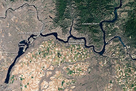
Banks Lake
Part of the Columbia Basin Project, Banks Lake occupies the northern portion of the Grand Coulee, a formerly dry coulee near the Columbia River, formed by the Missoula Floods during the Pleistocene epoch.
From the south end, the water stored in Banks Lake is distributed over a large region for irrigation of the Columbia Basin Project.
In contrast to the rugged, irregular contours of local peaks, cultivated land appears as a network of rectangles, some deep green, others beige or tan.
Bright green dots reveal fields watered with center-pivot irrigation systems.
Flatter terrain not under cultivation appears gray-beige, likely resulting from sparse vegetation, especially in the northwest.