Alpine Foreland
[1] The Alpine Foreland has been shaped under the influence of the ice ages and has a rich variety of landforms.
Features such as the morainic hills, gravel sandar and lakes have left a record of various glaciation stages in this region.
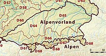
The Alpine Foreland is crossed by the rivers Iller, Wertach, Lech, Isar and Inn, its western boundary roughly being formed by the border of the Bavarian administrative district of Swabia with the State of Baden-Württemberg, and its eastern boundary being the Salzach river on the border with Austria.
According to the Handbook of Natural Region Divisions of Germany, the Alpine Foreland is commonly subdivided into three natural regions: In the west, the Alpine Foreland stretches along the Danube up to its sources in the Black Forest and beyond Lake Constance continues as the Swiss Plateau.
In the east, the Austrian Alpine Foreland comprises the Flachgau region of Salzburg, the adjacent Innviertel, Hausruckviertel and Traunviertel of Upper Austria, as well as the Mostviertel region of Lower Austria up to the Tulln Basin.