Benton County, Arkansas
Much of eastern Benton County is located along Beaver Lake, a reservoir of the White River.
The county's economy is heavily influenced by the presence of Walmart, headquartered in Bentonville, and hundreds of associated businesses, with agriculture, tourism, and construction also important sectors.
[2][3] Prior to white settlement of the county, the region was used by roving bands of Osage and Delaware who used the area for seasonal hunting grounds.
Initial white settlement on Benton County took place around Maysville around 1830, followed by areas around Garfield, Cross Hollow, and Centerton.
The first building serving as courthouse was the home of George P. Wallace, the first county judge, for the 1837 court term.
By the following year, a log structure on the north side of the Bentonville square was complete and served as the first permanent courthouse.
Court resumed after the war in a rented office for a few months until a new two-story frame building was constructed east of the county jail.
In 1870, the search for a more permanent home for county government began, and a new structure was finished after significant struggle and controversy, in 1874.
[6] On May 26, 2024, Benton County experienced the largest tornado in Arkansas history, an EF3 with a width of 1.8 miles (2.9 km).
[citation needed] Benton County is located within the Springfield Plateau subset of the Ozark Mountains.
The plateau is gently rolling compared to the steeper Boston Mountains to the south and east, and contains karst features such as springs, losing streams, sinkholes, and caves.
Application of poultry litter to agricultural fields is a non-point source that can impair water quality.
The eastern part of the county is drained by the White River, which includes Beaver Lake.
As of 2005 estimates, Benton County's population was 81.7% non-Hispanic white, while the percentage of Latinos grew by 60 percent in the time period.
1.1% of the population was African-American; 1.6% was Native American (the historical presence of the Cherokee Indians live in close proximity to Oklahoma); 1.7% was Asian (there was a large influx of Filipinos, Vietnamese and South Asian immigrants in recent decades) and 0.2% of the population was Pacific Islander.
[25] The historic Trail of Tears is on US highways 62 and 71 and connects with U.S. Route 412 in nearby Washington County.
It was one of the first counties in Arkansas to break from the Democratic Solid South, supporting Republicans Herbert Hoover in 1928 and Thomas E. Dewey in 1944.
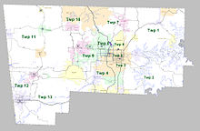
Each township includes unincorporated areas; some may have incorporated cities or towns within part of their boundaries.
However, the United States census does list Arkansas population based on townships (sometimes referred to as "county subdivisions" or "minor civil divisions").
Each town or city is within one or more townships in an Arkansas county based on census maps and publications.