Bothnian Bay
The bay today is fed by several large rivers, and is relatively unaffected by tides, so has low salinity.
The bay is divided from the Bothnian Sea, the southern part of the Gulf of Bothnia, by the Northern Quark (Kvarken) strait.
[8] Today the Bothnian Bay lies around 300 metres (980 ft) higher than it did at the end of the Last Ice Age.
[6] The local population has seen the sea retreating during their lifetimes from piers and boathouses, leaving them stranded on land.
Within 2,000 years, the exit from the bay at Kvarken will be raised above sea level, which will result in it becoming Europe's largest lake.
[19] The immediate coastal areas of the Bothnian Bay tend to be bordering between humid continental and subarctic climates.
Due to the mild nature of summers and the low diurnals, offshore islands tend to be humid continental since September usually stays above 10 °C (50 °F) means.
FMI(record highs and lows 1921–1961)[28] The Quark ridge at the south of the bay defines the dividing line beyond which many salt water species are unable to survive.
[9] The only filter feeders are Ephydatia and, at the river mouths, small numbers of freshwater mussels.
[33] Fish species found in the area's lakes and rivers also live in the bay, including roach, perch, pike and grayling.
[35] Birdlife includes the black guillemot, velvet scoter, oystercatcher, lesser black-backed gull, western capercaillie and willow ptarmigan.
Ports on the Finnish side include Haukipudas, Jakobstad, Kemi, Kokkola, Oulu, Raahe and Tornio.
[38] The largest towns by population on the Finnish side as of 2013 were Oulu (192,680), Tornio (22,374), Kemi (22,157), Kempele (16,549), Raahe (25,641), Kalajoki (12,637), Kokkola (46,697) and Jakobstad (19,636).
[3] On the Swedish side ports include Haparanda, Karlsborg, Kalix, Luleå, Piteå and Skellefteå.
The 1,312 islands of the Luleå archipelago are an important tourist attraction, as is the Gammelstad church village, listed as a Unesco World Heritage site.
[35] As of 1993 there were about 113,000 hectares (280,000 acres) of arable land in the Swedish part of the catchment basin, mostly used for small-scale low-intensity farming.
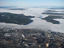
Agriculture, forestry and peat mining in the catchment basin add nutrients to the bay, affecting the ecological balance, while pollutants are delivered from steel mills and from pulp and paper mills around the bay, as well as from sewage treatment plants.
[2] Efforts have been made to reduce pollution through improved technology, but some areas along the Finnish coastline show evidence of eutrophication.