Cartography of New Zealand
[2] Initially surveys were done by measuring points on the ground and staking out areas, this was quickly followed in the late 1800s by the triangulation method.
[7] Prior to European colonisation, New Zealand was divided into territories of tribes (Iwi) and subtribes (hapu).
Early Polynesian explorers did, however, made stick diagrams to represent the distance and direction to islands.
[12] The first two European expeditions to map New Zealand (Abel Tasman and James Cook) were both trying to find the hypothesized continent of Terra Australis.
[14] Cook proved the absence of Terra Australis and made detailed maps of New Zealand.
[13][16] The first detailed maps and reports of abundant wildlife brought sealers then whales to New Zealand.
If negotiations were successful, the applicant was given a crown grant that gave them ownership under British law.
[19] With the start of the Otago gold rush and discovery of the Nelson mineral belt, geologists and surveyors were hired to map inland New Zealand.
He recommended that a unified map projection was adopted and a single system of reference points was established across the country.
[22] The chief surveyor of the Otago province, John Turnbull Thomson, was made surveyor-general of the new government survey department.
[18] In the years following Major Palmer's report, triangulation had been extended throughout New Zealand, but accuracy had been found wanting.
Work continued through World War II as the project was allowed topographical maps for military use to be quickly compiled.
This system is called the New Zealand Geodetic Datum 2000, and includes the NZ Transverse Mercator projection that topographical maps are published in.
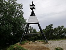
[23] These geodetic activities are responsible for the ubiquitous trig stations that reside mostly at the top of many hills throughout New Zealand.
It is a strip of public land, usually 20 metres (or one chain in pre-metric measure) wide along rivers, lakes and the coast line.
However, matters relating to surveying may require certification by a registered professional surveyor under contract law or local authority regulations.
Another oddity is the convention of writing coordinates where the northing is written before the easting, at odds with much of the rest of the world.