Centers of action
[5][6] The French meteorologist Léon Teisserenc de Bort was the first in 1881 to apply this term to maxima and minima of pressure on daily charts.
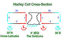
The thermal contrasts over oceanic waters leads to the formation of these centers of action as a direct convective circulation is established between the equator and higher latitudes in a very weak Coriolis force zone.
Similarly, low pressure areas are formed in the oceanic circulation near the Polar regions were sea water is much warmer than the land.
Apart from a thermal anticyclone over Australia during the southern winter, the centers of action are fairly stable over the oceans.
The southern parts of the Atlantic, Indian, and Pacific oceans have three anticyclones over the Horse latitudes.