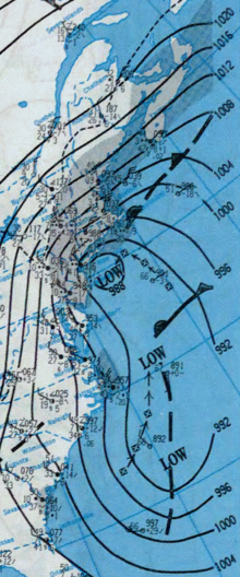
Christmas 1994 nor'easter
As it entered the warm waters of the Gulf Stream in the Atlantic Ocean, it began to rapidly intensify, exhibiting traits of a tropical system, including the formation of an eye.
It attained a pressure of 970 millibars on December 23 and 24, and after moving northward, it came ashore near New York City on Christmas Eve.
Widespread damage and power outages also occurred throughout Rhode Island and Massachusetts, where the storm generated 30-foot (9.1 m) waves along the coast.
The storm originated in an upper-level low pressure system that moved southeastward from the central Great Plains into the Deep South of the United States.
After reaching the southeast Gulf of Mexico, the disturbance underwent cyclogenesis, and the resultant system moved through Florida on December 22 in response to an approaching trough.
[1] Forecasters lacked sufficient data to fully assess the cyclone for potential tropical characteristics, and as such, it could not be classified.
The same trough that pushed the storm across Florida had moved to the north, allowing for high pressure to develop in the upper levels of the atmosphere.
[2] Deemed a "hybrid storm", the cyclone rapidly intensified in warm waters of up to 80 °F (27 °C) from the Gulf Stream combined with a cold air mass over the United States.
[3] The system continued to rapidly intensify while moving within the Gulf Stream; it developed central convection, an unusual trait for an extratropical cyclone, and at one point exhibited an eye.
[2] An upper-level low pressure system that developed behind the storm began to intensify and grew to be larger in size than the original disturbance.
In an interaction known as the Fujiwhara effect, the broad circulation of the secondary low swung the primary nor'easter northwestward towards southern New York and New England.
[3] The original low passed along the south shore of Long Island, and made landfall near New York City on December 24.
[13] As the primary storm entered New England, the secondary low produced minor coastal flooding in the Tidewater region of Virginia on December 23.
Roughly 112,000 Long Island Lighting Company customers experienced power outages at some point during the storm.
[4] As the cyclone progressed northward into New York State, high winds occurred in the Hudson Valley region.
[24] A man in Milford was killed indirectly when a tree that was partially downed by the storm fell on him during an attempt to remove it from a relative's yard.
Additionally, minor flooding was reported across the region, as a result of heavy surface runoff and small ice jams.
Reportedly, wind gusts approached 100 miles per hour (160 km/h) on Cape Cod and, offshore, waves reached 30 feet (9.1 m).
[31] Rainfall of 2 to 3.5 inches (51 to 89 mm) was recorded throughout the eastern part of the state, contributing to heavy runoff that washed away a 400-foot (120 m) section of a highway.

Tropical storm (39–73 mph, 63–118 km/h)
Category 1 (74–95 mph, 119–153 km/h)
Category 2 (96–110 mph, 154–177 km/h)
Category 3 (111–129 mph, 178–208 km/h)
Category 4 (130–156 mph, 209–251 km/h)
Category 5 (≥157 mph, ≥252 km/h)
Unknown
