Climate of Asia
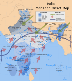
The monsoon circulation dominates across the southern and eastern regions, due to the Himalayas forcing the formation of a thermal low which draws in moisture during the summer.
The southwestern region of the continent experiences low relief as a result of the subtropical high pressure belt; they are hot in summer, warm to cool in winter, and may snow at higher altitudes.
Siberia is one of the coldest places in the Northern Hemisphere, and can act as a source of arctic air mass for North America.
Its poleward progression is accelerated by the onset of the summer monsoon which is characterized by the development of lower air pressure (a thermal low) over the warmest part of Asia.Mawsynram in Meghalaya received annually 11872 cm of rainfall[4][5][6] Cherrapunji.
After the arrival at the Eastern Himalayas, the winds turns towards the west, travelling over the Indo-Gangetic Plain at a rate of roughly 1–2 weeks per state[citation needed], pouring rain all along its way.
Indian agriculture (which accounts for 25% of the GDP and employs 70% of the population) is heavily dependent on the rains, for growing crops especially like cotton, rice, oilseeds and coarse grains.
It is estimated that about 70% of all precipitation in the central part of the Tian Shan Mountains falls during the three summer months, when the region is under the monsoon influence; about 70% of that is directly of "cyclonic" (i.e., monsoon-driven) origin (as opposed to "local convection").
[10] Around September, with the sun fast retreating south, the northern land mass of the Indian subcontinent begins to cool off rapidly.
This causes the cold wind to sweep down from the Himalayas and Indo-Gangetic Plain towards the vast spans of the Indian Ocean south of the Deccan peninsula.
While traveling towards the Indian Ocean, the dry cold wind picks up some moisture from the Bay of Bengal and pours it over peninsular India and parts of Sri Lanka.
[11] In Southern Asia, the northeastern monsoons take place from December to early March when the surface high-pressure system is strongest.
The subtropical flow directs northeasterly winds to blow across southern Asia, creating dry air streams which produce clear skies over India.
Meanwhile, a low pressure system develops over South-East Asia and Australasia and winds are directed toward Australia known as a monsoon trough.
On November 12, 1970, a cyclone struck Bangladesh, then known as East Pakistan, producing a 6.1 m (20 ft) storm surge that killed at least 300,000 people.
[17] In neighboring Myanmar, Cyclone Nargis struck the low-lying Irrawaddy Delta in May 2008 with strong winds and a 3.7 m (12 ft) storm surge.
[23][24][25] The Pacific Ocean north of the equator is the most active tropical cyclone basin on Earth, accounting for roughly one-third of all storms annually.
[28][29][30] Typhoons – the regional name for an intense tropical cyclone – affect southeastern Asia more often during La Niña years, due to the westward position of the subtropical ridge.
By 2080, around 1 billion people in the cities of South and Southeast Asia are expected to experience around a month of extreme heat every year.
[33]: 1465 There are many coral reefs in the region, and they are highly vulnerable to climate change,[33]: 1459 to the point practically all of them will be lost if the warming exceeds 1.5 °C (2.7 °F).
[33]: 1459 These changes to water cycle also affect vector-borne disease distribution, with malaria and dengue fever expected to become more prominent in the tropical and subtropical regions.
[33]: 1470 While nearly half of the world's new renewable energy capacity is built in Asia,[33]: 1470 this is not yet sufficient in order to meet the goals of the Paris Agreement.