Geography of the United Arab Emirates
The United Arab Emirates is situated in the Middle East and West Asia, bordering the Gulf of Oman and the Persian Gulf, between Oman and Saudi Arabia; it is at a strategic location along the northern approaches to the Strait of Hormuz, a vital transit point for world crude oil.
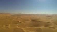
[5] South and west of Abu Dhabi, vast, rolling sand dunes merge into the Rub' al Khali (Empty Quarter) of Saudi Arabia.
[3] The desert area of Abu Dhabi includes two important oases with adequate underground water for permanent settlements and cultivation.
[3] Prior to withdrawing from the area in 1971, Britain delineated the internal borders among the seven emirates in order to pre-empt territorial disputes that might hamper formation of the federation.
[3] The Western Hajar Mountains (Jibāl Al-Ḥajar Al-Gharbī), rising in places to 2,500 m (8,200 ft), separate Al-Batinah coast from the rest of the UAE.
[3] Rain in the coastal region falls in short, torrential bursts during the summer months, sometimes resulting in floods in ordinarily dry wadi beds.
[3] The Jebel Jais mountain cluster in Ras Al Khaimah has experienced snow only four times (2004, 2009, 2017 and 2020) since records began.
The region's indigenous fauna had previously come close to extinction due to intensive hunting, which led to a 1970s conservation program on the Bani Yas island by Sheikh Zayed bin Sultan Al Nahyan; this resulted in the survival of Arabian oryxes and leopards, among others.