Geography of Lebanon
Lebanon's mountainous terrain, proximity to the sea, and strategic location at a crossroads of the world were decisive factors in shaping its history.
[1] The merchants of the region exported oil, grain, textiles, metal work, and pottery through the port cities to Western markets.
[1] Because Lebanon straddles the northwest of the Arabian Plate, it is sometimes geopolitically grouped together with nations with adjacent tectonic proximations such as Syria, Yemen, Oman, Qatar, Bahrain, Kuwait, Iraq, Saudi Arabia, Jordan, the Egyptian Sinai, Palestine, Israel and the UAE.
[1] Thus, the Beqaa Valley is part of the Great Rift system, which stretches from southern Turkey to Mozambique in Africa.
[1] A major feature of Lebanese topography is the alternation of lowland and highland that runs generally parallel with a north-to-south orientation.
[1] Hemmed in between sea and mountain, the sahil, as it is called in Lebanon, is widest in the north near Tripoli, where it is only 6.5 kilometres (4.0 mi) wide.
[1] A few kilometers south at Juniyah the approximately 1.5-kilometer-wide plain is succeeded by foothills that rise steeply to 750 metres (2,460 ft) within 6.5 kilometres (4.0 mi) from the sea.
[1] Ahl al Jabal ("people of the mountain"), or simply jabaliyyun, has referred traditionally to the inhabitants of western Lebanon.
Geologically, the Beqaa is the medial part of a depression that extends north to the western bend of the Orontes River in Syria and south to Jordan through Arabah to Aqaba, the eastern arm of the Red Sea.
[1] This fourth geographical region falls swiftly from Mount Hermon to the Hawran Plateau, whence it continues through Jordan south to the Dead Sea.
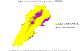
[1]Lebanon has a Mediterranean climate characterized by a long, hot, and dry summer, and a cool, rainy winter.
[1] A hot wind blowing from the Egyptian desert called the khamsin (Arabic for "fifty"), may provide a warming trend during the fall but more often occurs during the spring.
[1] In the Lebanon Mountains the gradual increase in altitudes produces extremely cold winters with more precipitation and snow.
[1] The influence of the Mediterranean Sea is abated by the altitude and, although the precipitation is even higher than it is along the coast, the range of temperatures is wider and the winters are more severe.
[1] The Beqaa Valley is watered by two rivers that rise in the watershed near Baalbek: the Orontes flowing north (in Arabic it is called Nahr al-Asi, "the Rebel River", because this direction is unusual), and the Litani flowing south into the hill region of the southern Biqa Valley,[1] where it makes an abrupt turn to the west in southern Lebanon.
[1] There is one seasonal lake, fed by springs, on the eastern slopes of the Lebanon Mountains near Yammunah, about 40 kilometres (25 mi) southeast of Tripoli.
[10] The coastal strip of Lebanon gets approximately 2,000 mm of rain per year, while the Beqaa Valley to the east gets only one-tenth as much.
[10] It is predicted that in future years, there will be higher temperatures, lower rainfall, and longer droughts, leading to even less access to water.
Currently, over 48 percent of water supplied by the public system is lost through seepage and wastewater networks are extremely poor, or even non-existent in some areas.
[14] This would be a huge improvement, as solid-wast treatment facilities are in short supply, and over 92 percent of Lebanon's sewage runs untreated directly into water-courses and the sea.
Lebanon's rugged terrain historically helped isolate, protect, and develop numerous factional groups based on religion, clan, and ethnicity.
[16] Approximately 93 percent of Beirut's population is exposed to high levels of air pollution, which can most often be attributed to vehicle-induced emissions, whether it be long-range travel or short commuting traffic.
[17] Some recommendations for improvement of air quality include encouragement of carpooling and citywide biking, alternative fuels for vehicles, and a widened public transit sector.
Between 2013 and 2017, the Lebanese ministry of environment was granted a donation of over 10 million Euros by Greece and the European Union to establish a national air monitoring network, which included at its peak 25 stations.
[18] This network was launched in October 2017 at a major event bringing together 26 different institutions;[19] it was to serve as the cornerstone of Lebanon's National Strategy for Air Quality Management, which was released at the end of the same year.
[22] In January 2014, protests in the town of Naameh began to arise, effectively blocking disposal of garbage at the landfill for three days.
[23] In response to the protests, which were asking the government for more efficient waste management systems along with the closure of the landfill in Naameh, Sukleen responded to environmentalists by halting service to Beirut and Mount Lebanon for three days.