Geography of Singapore
Singapore is a city-state and island country in maritime Southeast Asia, located at the end of the Malayan Peninsula between Malaysia and Indonesia as well as the Straits of Malacca and the South China Sea.
These figures are based on 2.515 metres (8 ft 3.0 in) High Water Mark cadastral survey boundaries.
The highest point of Singapore is Bukit Timah Hill, with a height from the ground of 165 m (538 ft) and made up of igneous rock, granite.
Hills and valleys of sedimentary rock dominate the northwest, while the eastern region consists of sandy and flatter land.
Singapore has reclaimed land with earth obtained from its own hills, the seabed, and neighboring countries.
Owing to its geographical location and maritime exposure, its climate is characterised by uniform temperature and pressure, high humidity and abundant rainfall.
Generally, there is much more rainfall on the western side of the island than on the eastern portion of Singapore, owing to a rain shadow effect.
It has taken a three-prong approach to the issue - researching how the nation will be affected in specific details, implementing mitigation measures and adapting to the coming changes.
[17] To reduce the country's dependence on fossil fuels, it is building one of the world's largest floating solar farms at Tengeh Reservoir in Tuas, with a capacity of 60MW.
Sedimentary rocks are found on the western part of Singapore and is mainly made of sandstone and mudstones.
However, the population and buildings are prone to being only very slightly affected by any activity as tremors, which is not uncommon, but generally does not do any harm and is limited to small amounts of swaying or vibration of objects.
In late 2004, several parts of Asia and Africa were struck by the 2004 Indian Ocean earthquake and the resulting tsunami.
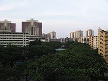
However, since the 1960s the government has constructed many new towns in other areas, so that today the island is nearly entirely built-up and urbanised, with only a few exceptions, such as the district of Lim Chu Kang or reclaimed land in the process of being developed.
However, unlike other countries where local government subdivisions are used to cite locations, the same practice is often uncommon in Singapore.
Political boundaries fluctuate with every general election and thus, the areas they cover do not necessarily correspond to the local perception of a place.
As the main government agency responsible for the urban planning of Singapore, the Urban Redevelopment Authority seeks to implement efficient land use and minimise pollution while maintaining convenient transport, which are Singapore's largest concerns because of its situation as a city-state.
In order to reduce traffic congestion, Electronic road pricing (ERP) has been enacted around entrances into the Central Area.
However, to reduce strain on the Central Area, several regional centres have been developed, each containing a concentrated commercial district.
The causeway (1,038 m in length) was designed by Coode, Fizmaurice, Wilson and Mitchell of Westminster and constructed by Topham, Jones & Railton Ltd of London.
Since Singapore lacks natural freshwater rivers and lakes, the primary source of domestic water is rainfall.
Recent plans to produce NEWater-recycled water from treatment by filtration via reverse osmosis have been very successful as the government has opened up three plants around the island to help meet the demand.
[21] Singapore remains highly vulnerable to the impact of climate change; in particular, the rising sea levels may pose a major threat to the very survival of the country in the long-term perspective.