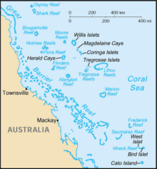
Coral Sea
The reefs and islands of the Coral Sea are particularly rich in birds and aquatic life and are a popular tourist destination, both domestically and internationally.
On the west, it is bounded by the mainland coast of Queensland, and in the northwest, it connects with the Arafura Sea through the Torres Strait.
To the north of the Great Barrier Reef the Eastern and Papuan Plateaus continue the southern continental shelf of New Guinea.
This current is the strongest along the Australian coasts and transforms 30 million m3/s of water within a flow band of about 100 kilometres wide and 500 metres deep.
[23] Climate change made it 175 times more likely that the surface waters of the Coral Sea would reach the record-breaking temperatures March 2016 that bleached reefs, modelling analysis showed.
[29] The sea hosts numerous species of anemones, sponges, worms (e.g. Spirobranchus giganteus shown in the photograph), gastropods, lobsters, crayfish, prawns and crabs.
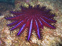
[34] Crown-of-thorns starfish (Acanthaster planci) is the major predator of the reefs, as it preys upon coral polyps by climbing onto them, extruding its stomach over them, and releasing digestive enzymes to absorb the liquefied tissue.
[37] Changes in water quality and overfishing of natural predators, such as the giant Triton, may have contributed to an increase in the number of crown-of-thorns starfish.
[43][44] Seventeen species of sea snake, including Laticauda colubrina[45] (pictured), live on the GBR in warm waters up to 50 metres (160 ft) deep and are more common in the southern than in the northern section; none of them are endemic or endangered.
[50] With a maximum total length of 0.84 cm (0.33 in), Schindleria brevipinguis, which is native to the GBR and Osprey Reef, is one of the smallest known fish and vertebrate.
The interaction rate (free diving) at the Coral Sea reefs ranged from a few to 26 sharks per hour.
[55] The rare Etmopterus dislineatus shark species is endemic to the central part of the Coral Sea.
[56] The coastal areas of the Coral Sea were populated at least 40,000 years ago by prehistoric people descending through the northern islands.
Navigation has long been a traditional human activity on the Coral Sea and there are 10 major ports on the Queensland coast alone.
More than 3,500 ships operated in this area in 2007, making over 9,700 voyages that transported coal, sugar, iron ore, timber, oil, chemicals, cattle and other goods.
[59] Other economic activities in the sea include fishing and exploration of petroleum deposits in the Gulf of Papua.
[61] Growing concerns over the environmental effects of tourism resulted in establishment in 1975 of the Great Barrier Reef Marine Park.
[11] From the middle of 2004, approximately one-third of the GBR Marine Park is protected from species removal of any kind, including fishing, without written permission.
After the Commonwealth Petroleum Search Subsidies Act of 1957, hydrocarbon exploration increased in Queensland, including a well drilled at Wreck Island in the southern Great Barrier Reef in 1959.
[63] In the 1960s, drilling for oil and gas was investigated throughout the Great Barrier Reef,[64][65] in the Torres Strait, along "the eastern seaboard of Cape York to Princess Charlotte Bay" and along the coast from Cooktown to Fraser Island.
About thirty rivers and hundreds of small streams add continental water, which contains sediments, pesticides and industrial waste.
[71] On 3 April 2010, the Chinese ship Shen Neng 1 carrying 950 tonnes of oil, ran aground east of Rockhampton in Central Queensland, Australia,[72] causing the 2010 Great Barrier Reef oil spill and inflicting the largest damage to the GBR and the Coral Sea so far.
[73] The scarred area was roughly 3 km (1.9 mi) long and 250 m (820 ft) wide,[74] and some parts of it have become completely devoid of marine life.
[75] By 13 April 2010, oil tar balls were washing up on the beaches of North West Island, a significant bird rookery and turtle nesting colony.
[77] In November 2011 the Australian government announced that a 989,842 square kilometres (382,180 sq mi) protected area was planned and pending approval.
During 2020 some of the deepest parts of the sea were mapped using an advanced multi-beam sonar system aboard a research ship owned by the Schmidt Ocean Institute, after it was diverted from a Papua New Guinea deployment because of the pandemic.
A robotic submarine sent back the first ever high-resolution footage and seafloor mapping of the vital marine protected area connecting the Great Barrier Reef to the Pacific Ocean.
An area of 35,554 square kilometres (13,727 sq mi) was mapped, during 14 dives by the submarine, which went down up to 1,600 metres (5,200 ft) into the depths and spent almost 100 hours in the sea.
Rare marine life was identified after the images were shared with other scientists on social media, but researchers think that some of the species captured on film could be entirely new to science.
Notable finds included a species of spikefish called Hollardia goslinei, previously only seen in Hawaii, and Tosanoides bennetti, first described in 2019 and never seen alive.