Cross County, Arkansas
The county is largely flat and fertile, mostly used for row agriculture typical of the rich alluvial soils of the Arkansas Delta.
Crowley's Ridge, a forested deposit of loess hills rising from the flat Delta bisects the county from north to south, including part of Wynne and most of Village Creek State Park, the county's primary protected area of ecological value.
Historical and cultural features range from Parkin Archeological State Park, which preserves a prehistoric Native American mound building settlement, to the Johnston Cotton Gin marking mechanization of the cotton farm, and the Northern Ohio School, a segregated school built by a lumber company for African-American children of employees.
Cross County occupies 622.33 square miles (1,612 ha) and contained a population of 16,833 as of the 2020 census.
Bisecting the county from north to south is Crowley's Ridge, a geologic anomaly rising from the Delta composed of loess soil and generally remains covered in oak-hickory forest.
This region is characterized as flat windblown deposits of silty, sandy soils, and loess with a high groundwater table.
Today, row agriculture is extensive (mostly soybeans and cotton), with commercial aquaculture (crawfish, baitfish, and catfish farms) also common.
[10] Crowley's Ridge is a series of loess hills more closely associated with the Appalachian Mountains of Tennessee and Kentucky than the Delta country surrounding it.
Composed of sandy loess stacked on gravel deposits later eroded by streams into ravines, Crowley's Ridge rises from the flat Delta by up to 500 feet (150 m).
[10] The eastern third of Cross County is split between the Northern Holocene Meander Belts and St. Francis Lowlands, both subregions historically influenced by the Mississippi River.
Today consisting of farm fields, channelized drainage ditches, levees, the area is predominantly in soybean and cotton cultivation, with some corn, wheat, rice, and sorghum.
Remaining natural areas consist of sugarberry, elm, ash tree, pecan, cottonwood, and sycamores.
[10] Given Cross County's position along the Mississippi Flyway, many natural areas and grain fields serve as wintering ground for water fowl.
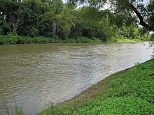
The deep, wide, calm, and navigable St. Francis River has been important for every civilization in Cross County since prehistory.
[13] The largest protected area in Cross County is Village Creek State Park on Crowley's Ridge near Wynne.
The Brushy Creek Wildlife Management Area is a small property reforested in bottomland hardwood forest by the Arkansas Game and Fish Commission near Hickory Ridge.
The agency is led by the Cross County Sheriff, an official elected by countywide vote every four years.
Local district courts are presided over by an elected part-time judge who may privately practice law.
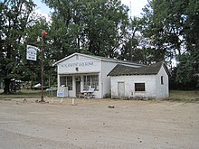
Cross County has several facilities, monuments, and museums dedicated to preserving the history and culture of the area.
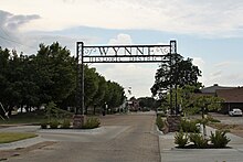
Wynne was the primary beneficiary of transportation improvements following the Reconstruction era, becoming a commercial hub for Cross County.
The county has had several former publications that have closed over the years, including newspapers published at Parkin and Wittsburg.
[36] Cross County is within the Memphis designated market area[37] with the following local TV stations: WREG (CBS), WMC (NBC), WKNO (PBS), WHBQ (Fox), WTWV, WATN (ABC), WLMT (The CW), WBUY, and WPXX (Ion TV).
The quorum court is the legislative branch of the county government and controls all spending and revenue collection.
[42][43] Politically, Cross County has transitioned from reliably Democratic to steadily Republican since the mid-20th century.
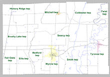
However, the United States census does list Arkansas population based on townships (sometimes referred to as "county subdivisions" or "minor civil divisions").
Each town or city is within one or more townships in an Arkansas county based on census maps and publications.
Highway 42 runs east–west across the northern part of Cross County through Hickory Ridge, Cherry Valley, Birdeye, Coldwater, and Twist.
Highway 75 runs north–south through east Cross County, connecting Parkin and Coldwater to I-40 to the south and I-555 to the north.
The Arkansas Department of Health (ADH) is responsible for the regulation and oversight of public water systems throughout the state.