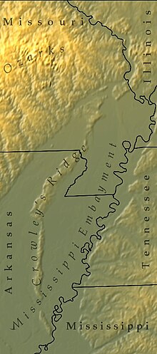
Crowley's Ridge
It is the most prominent feature in the Mississippi Alluvial Plain between Cape Girardeau, Missouri, and the Gulf of Mexico.
This narrow rolling hill region rising above the flat plain is the sixth, and smallest, natural division of the state of Arkansas.
The highest point on the ridge in Arkansas is "Legacy Mountain" at the Craighead County solid waste site south of Jonesboro.
[4] Recent seismic evidence, however, questions the fluvial origin by focusing on uplift along ridge bounding faults.
[5] The flora and fauna of the ridge seem more closely related to the Tennessee hills to the east than to the Ozark Mountains to the west.
[8] The region adjacent to the ridge is covered with thick deltaic soils, and few fossils are found except in gravel pits.
These pits sometimes reveal the teeth of large mastodons, mammoths and horses, which roamed the continent as recently as 10,000 years ago.
Near Forrest City, in the bed of Crow Creek, a deposit of oyster shells estimated to be nearly 7,000,000 cubic yards in size was discovered.
Crowley is buried in the Shiloh Cemetery in Greene County, Arkansas, and a monument marks the spot.