Cyclone Fantala
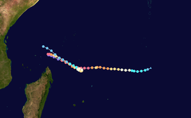
Part of the 2015–16 cyclone season, Fantala formed on 11 April to the south of Diego Garcia, an island in the central Indian Ocean.
With a ridge to the south, the storm moved westward for several days while gaining strength, aided by warm waters and decreasing wind shear.
Later on 18 April, Fantala had weakened to an intense tropical cyclone and slowed its forward motion, eventually reversing its direction of movement.
Limiting factors to faster development included poor inflow and moderate wind shear, although associated convection became more organized.
At 06:00 UTC on 11 April, the Regional Specialized Meteorological Center Météo-France in La Réunion (MFR) classified the system as Tropical Disturbance 8 about 600 km (370 mi) south of Diego Garcia.
[3] At 13:00 UTC on 11 April, the American-based Joint Typhoon Warning Center (JTWC) issued a tropical cyclone formation alert, noting the increased organization of the convection, circulation, and outflow.
[8] At 12:00 UTC on 12 April, the MFR upgraded Fantala to severe tropical storm status,[9] and six hours later, the JTWC upgraded it to the equivalent of a minimal hurricane, with 1 minute maximum sustained winds of 120 km/h (75 mph); rapid strengthening was prevented by the entrainment of nearby dry air,[10] although the core of convection continued to contract.
[12] By that time, the eye feature persisted, consisting of a warm area within the deepest convection,[13] although the dry air in the region prevented quicker strengthening.
[20] Intensification resumed by 12:00 UTC on the following day, with the JTWC estimating 1-minute sustained winds of 270 km/h (165 mph), classifying Fantala as a Category 5-equivalent tropical cyclone on the Saffir-Simpson scale.
[21] However, in the best track for Fantala, the MFR concluded that Fantala had been a very intense tropical cyclone 6 hours earlier as well, with 10-minute sustained winds of 220 km/h (140 mph), and that the storm's peak intensity and minimum central pressure of 910 mbar (910 hPa; 27 inHg) had occurred 18 hours after that time, at 06:00 UTC on 18 April.
[22] The cyclone turned back to the southeast due to the building influence of a ridge to the northeast, and the storm retraced its former path.
Cooler waters along its path[23] – the result of upwelling[24] – as well as another eyewall replacement cycle,[25] caused Fantala to weaken to an intense tropical cyclone by 19 April.
[45] In a visit to the Seychelles, United Nations Secretary-General Ban Ki-moon stated that the country has become "highly vulnerable to storm surges, as we are reminded by the recent devastating effects of Cyclone Fantala.
[49] In Kilimanjaro Region, the rains caused flooding that covered roads and entered houses, trapping hundreds of residents and killing eight.
Flooding also washed away 12,073 ha (29,830 acres) of crop fields, prompting officials to purchase and distribute maize, beans, and cooking oil to affected residents.
[52] The MFR's estimate of peak 10-minute sustained winds of 250 km/h (155 mph)[12] made Fantala the strongest tropical cyclone on record in the south-west Indian Ocean by that measure.
Tropical storm (39–73 mph, 63–118 km/h)
Category 1 (74–95 mph, 119–153 km/h)
Category 2 (96–110 mph, 154–177 km/h)
Category 3 (111–129 mph, 178–208 km/h)
Category 4 (130–156 mph, 209–251 km/h)
Category 5 (≥157 mph, ≥252 km/h)
Unknown

