Cyclone Gafilo
[1] Gafilo also caused about $250 million (2004 USD) damages in Madagascar, which makes it one of the most devastating storms to hit the country on reliable record.
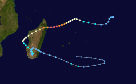
When the system slowed and tracked west-northwestwards along the northern periphery of a building subtropical ridge, it reached category 1 strength on the Saffir–Simpson hurricane wind scale late on 3 March.
[5] Although dry air significantly reduced deep convection on 4 March, MFR upgraded Gafilo to a tropical cyclone due to a banding eye, when the system began to expand its clockwise circulation and track west-southwestwards.
[8] Therefore, MFR upgraded Gafilo to a very intense tropical cyclone with a very well-defined circular and warm 20 nautical miles (37 km; 23 mi) diameter eye at 06Z, when it also reached category 5 strength on the Saffir–Simpson hurricane wind scale.
[9] At 12Z, Gafilo attained its peak intensity by the ten-minute maximum sustained winds reaching 125 knots (232 km/h; 144 mph) and the atmospheric pressure decreasing to 895 hPa (26.4 inHg), although microwave imagery showed that the eyewall replacement cycle had begun.
[10] Shortly after slightly weakening due to land interaction, Gafilo made landfall in the vicinity of Antalaha, Madagascar early on 7 March.
[12] Before noon on 8 March, Gafilo arrived at the Mozambique Channel as a moderate tropical storm whose strongest winds were located in the northern sector.
Surprisingly, MFR began to issue warnings again on the completely disorganised system at noon on 12 March, as the residual centre was expected to go back overseas.
Late on the same day, JTWC issued a Tropical Cyclone Formation Alert on the overland remnants, because of improved deep convection over the low-level circulation centre, poleward outflow and weak vertical wind shear.
[16] Gafilo transferred into a subtropical depression south of La Réunion on 14 March, when the deep convective activity was intensifying with better organisation of a small cluster above the low-level circulation centre due to good upper-level divergence and a warm sea surface temperature of 26 °C to 29 °C.
[11] Despite being located 300 km (190 mi) north of Gafilo's centre, the wreck of the ferry 'Samson' still happened on the night of 7 March, offshore the northwestern port of Mahajanga.
This created anarchy in the national parks in the Sava Region, with loggers extracting a large quantity of rosewood and ebony, grossly disproportionate to the amount of damage caused by the storm.
[25][27] Exports were also authorized following cyclones in 2006 and 2007, encouraging the stockpiling of large quantities of lumber in both legal depots and hidden caches around the ports of Vohémar and Antalaha.
Tropical storm (39–73 mph, 63–118 km/h)
Category 1 (74–95 mph, 119–153 km/h)
Category 2 (96–110 mph, 154–177 km/h)
Category 3 (111–129 mph, 178–208 km/h)
Category 4 (130–156 mph, 209–251 km/h)
Category 5 (≥157 mph, ≥252 km/h)
Unknown

