Cyclone Kesiny
The final named storm of the busy 2001–02 South-West Indian Ocean cyclone season, Kesiny formed on May 2 from a trough near the equator.
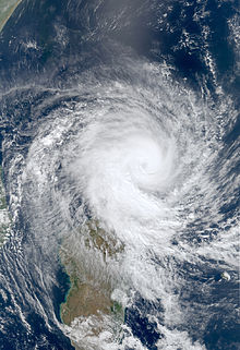
However, Kesiny developed an eye and re-intensified into a tropical cyclone on May 9, reaching peak winds of 130 km/h (81 mph) before striking Madagascar about 60 km (37 mi) southeast of Antsiranana.
Across Madagascar, Cyclone Kesiny dropped heavy rainfall, reaching 891 mm (35.1 in) in three days at Toamasina, the second largest city in the country.
The rains caused mudslides and flooding in the eastern portion of the country, wrecking the rice and maize crops and leaving 5,000 people homeless.
In late April 2002, an area of convection, or thunderstorms, persisted to the west-southwest of Diego Garcia in the south-central Indian Ocean, associated with a trough near the equator.
Such simultaneous systems in opposite hemispheres occasionally occur in the spring or autumn; in May 2002, the powerful MJO pulse produced two such sets of storms, later producing a set in the eastern Indian Ocean that became a deep depression that struck Myanmar and Tropical Storm Errol to the southwest of Indonesia.
[3] The thunderstorms became more concentrated around an increasingly well-defined center, and with minimal wind shear, the system strengthened into Tropical Depression 14 on May 3.
[1] Developing rainbands and a central dense overcast, the depression intensified into Tropical Storm Kesiny early on May 4.
[3] Early on May 6, the JTWC upgraded the storm to the equivalent of a minimal hurricane, with maximum 1 minute sustained winds of 120 km/h (75 mph).
The three-day total of 136 mm (5.4 in) in Antsiranana was eight times the average May precipitation, and occurred at the start of harvesting for rice and maize.
In Nosy Be, an island offshore northwestern Madagascar, Kesiny capsized a few boats, and killed two people after a house collapsed.
[8] The political crisis caused difficulties after the storm in distributing food,[9] and Ratsiraka's operational center in the city was damaged.
Workers from the World Health Organization and Médecins Sans Frontières (Doctors Without Borders) provided medical assistance to residents in Toamasina during the storm.

Tropical storm (39–73 mph, 63–118 km/h)
Category 1 (74–95 mph, 119–153 km/h)
Category 2 (96–110 mph, 154–177 km/h)
Category 3 (111–129 mph, 178–208 km/h)
Category 4 (130–156 mph, 209–251 km/h)
Category 5 (≥157 mph, ≥252 km/h)
Unknown