Cyclone Kimi
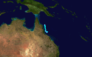
The low strengthened into Tropical Cyclone Kimi early the next day, as it slowly moved towards the coastline of northeastern Australia.
Despite most forecasts depicting a track south into the coast, a vigorous increase in wind shear made the storm shift west away from the coastline just hours ahead of a potential landfall and caused Kimi to significantly weaken, becoming a tropical low by 18 January and dissipating entirely the next day.
Impacts were anticipated to be significant, with the effects of the previous storm to hit the state at the time, Cyclone Imogen, to be exacerbated from the heavy rainfall if it had made landfall.
On 12 January, the Bureau of Meteorology noted that a monsoonal trough could develop within a week, that would make conditions in the Australian Region basin favorable for tropical cyclogenesis.
[2] Later that day, the Joint Typhoon Warning Center (JTWC) issued a Tropical Cyclone Formation Alert on the system.
[5] Late on 17 January, radar imagery from Cairns showed low-level convective rainbands, which wrapped into the storm's center of circulation.
[11] On 17 January, a Tropical Cyclone Warning was put in effect from Cape Melville to Cardwell in Queensland, which extended inland to Palmer and Chillagoe.
[26] Areas still received flash flooding despite the absence of a direct hit from Kimi, most notably around Innisfail, which recorded some of the highest rainfall totals including a 158 mm (6.22 in) reading at a gauge in the town.
Tropical storm (39–73 mph, 63–118 km/h)
Category 1 (74–95 mph, 119–153 km/h)
Category 2 (96–110 mph, 154–177 km/h)
Category 3 (111–129 mph, 178–208 km/h)
Category 4 (130–156 mph, 209–251 km/h)
Category 5 (≥157 mph, ≥252 km/h)
Unknown
