Cyclone Sitrang
Immediately the Joint Typhoon Warning Centre (JTWC) issued a Tropical Cyclone Formation Alert (TCFA) on the system by 15:00 UTC on 22 October.
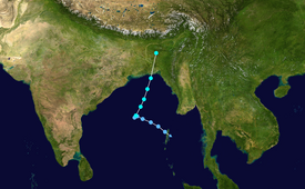
[8] When it made landfall over Bangladesh close to Patuakhali in Barisal on the early hours of 25 October (local time), the cyclone began to lose strength and was downgraded to a deep depression.
[9] Afterwards, Sitrang continued to weaken and in its thirteenth and final bulletin, the IMD declared that the cyclone had degenerated to a low pressure area by 06:00 UTC on 25 October.
[15] The Bangladeshi authorities evacuated thousands of people to shelters as the cyclone moved northward from the Bay of Bengal and approached Bangladesh's extensive coastline.
The government also requested fishing boats to return from the deep sea and remain anchored in the Bay of Bengal, closed three airports, and stopped all river transportation operations throughout the nation.
Tropical storm (39–73 mph, 63–118 km/h)
Category 1 (74–95 mph, 119–153 km/h)
Category 2 (96–110 mph, 154–177 km/h)
Category 3 (111–129 mph, 178–208 km/h)
Category 4 (130–156 mph, 209–251 km/h)
Category 5 (≥157 mph, ≥252 km/h)
Unknown