Instrument approach
The ICAO defines an instrument approach as "a series of predetermined maneuvers by reference to flight instruments with specific protection from obstacles from the initial approach fix, or where applicable, from the beginning of a defined arrival route to a point from which a landing can be completed and thereafter, if landing is not completed, to a position at which holding or en route obstacle clearance criteria apply.
Examples include baro-VNAV, localizer type directional aid (LDA) with glidepath, LNAV/VNAV and LPV.
Each procedure chart uses a specific type of electronic navigation system such as an NDB, TACAN, VOR, ILS/MLS and RNAV.
A cross depicts the final approach fix (FAF) altitude on NPAs while a lightning bolt does the same for PAs.
Finally, the chart depicts the missed approach procedures in plan and profile view, besides listing the steps in sequence.
[4]: 4–9, 4–11, 4–19, 4–20, 4–41 Before satellite navigation (GNSS) was available for civilian aviation, the requirement for large land-based navigation aid (NAVAID) facilities generally limited the use of instrument approaches to land-based (i.e. asphalt, gravel, turf, ice) runways (and those on aircraft carriers).
GNSS technology allows, at least theoretically, to create instrument approaches to any point on the Earth's surface (whether on land or water); consequently, there are nowadays examples of water aerodromes (such as Rangeley Lake Seaplane Base in Maine, United States) that have GNSS-based approaches.
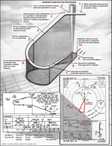
An instrument approach procedure may contain up to five separate segments, which depict course, distance, and minimum altitude.
The ceiling must be reported or expected to be at least 1000 feet AGL (above ground level) and the visibility is at least 3 SM (statute miles).
The point is that if a pilot is familiar with the terrain in the vicinity of the airfield he/she may easily find the way to the airport having the surface in sight.
ATC must ensure that weather conditions at the airport are above certain minima (in the U.S., a ceiling of 1000 feet AGL or greater and visibility of at least 3 statute miles) before issuing the clearance.
Once the pilot has accepted the clearance, he/she assumes responsibility for separation and wake turbulence avoidance and may navigate as necessary to complete the approach visually.
Pilots must have a charted visual landmark or a preceding aircraft in sight, and weather must be at or above the published minimums.
The TAA is a transition from the en route structure to the terminal environment which provides minimum altitudes for obstacle clearance.
The TAA is a "T" or "basic T" design with left and right base leg IAFs on initial approach segments perpendicular to the intermediate approach segment where there is a dual purpose IF/IAF for a straight-in procedure (no procedure turn [NoPT]), or hold-in-lieu-of procedure-turn (HILPT) course reversal.
[8] This type of approach takes advantage of the runway or more commonly, the oil platform, standing out from its surrounding environment when viewed on a radar.
With a horizontal situation indicator (HSI) system, reverse sensing is eliminated if it is set appropriately to the front course.
The specific values for DH and/or DA at a given airport are established with intention to allow a pilot sufficient time to safely re-configure an aircraft to climb and execute the missed approach procedures while avoiding terrain and obstacles.
While a DH/DA denotes the altitude at which a missed approach procedure must be started, it does not preclude the aircraft from descending below the prescribed DH/DA.
The idea of a course reversal is to allow sufficiently large changes in the course flown (in order to line the aircraft up with the final approach course), without taking too much space horizontally and while remaining within the confines of protected airspace.
Circling to land is considered more difficult and less safe than a straight-in landing, especially under instrument meteorological conditions because the aircraft is at a low altitude and must remain within a short distance from the airport in order to be assured of obstacle clearance (often within a couple of miles, even for faster aircraft).
If the ceiling allows, pilots are recommended to fly closer to the airport's pattern altitude for a safer operation.
[12]: 10–20 Pilots should be aware that there are significant differences in obstacle clearance criteria between procedures designed in accordance with ICAO PANS-OPS and US TERPS.
This is especially true in respect of circling approaches where the assumed radius of turn and minimum obstacle clearance are markedly different.
There must be redundant electrical systems so that in the event of a power failure, the back-up takes over operation of the required airport instrumentation (e.g., the ILS and lighting).
In general, each specific instrument approach specifies the minimum weather conditions that must be present in order for the landing to be made.