Digital outcrop model
[2] Using remote sensing techniques enables these 3D models to cover areas with difficult accessibility, e.g. several meter high cliff walls.
The fact that geological interpretation can be performed on the screen, also in inaccessible areas where using conventional fieldwork methods may be unsafe, and the large quantity of data that can be collected in relatively short time are the key advantages of using DOMs.
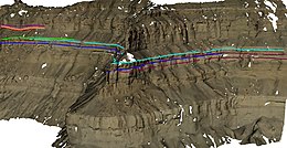
Such surface model representation accurately describes the topography of the outcrop but due to its discrete nature is often difficult to interpret (see Figure 1.).
[2] Creation of textured DOMs can be divided into three main steps: In order to achieve the required model resolution and accuracy data are mostly collected from the ground[2] (terrestrial) or from a helicopter platform (mobile mapping).
[citation needed] Due to their 3D nature digital outcrop models provide correct and accurate measures of the features listed in the next section.