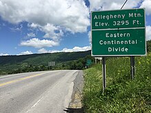
Eastern Continental Divide
It is one of six continental hydrological divides of North America which define several drainage basins, each of which drains to a particular body of water.
The divide nearly spans the United States from south of Lake Ontario through the Florida peninsula, and consists of raised terrain including the Appalachian Mountains to the north, the southern Piedmont Plateau and lowland ridges in the Atlantic Coastal Plain to the south.
[2] In Maryland, the Divide runs significantly west of the Allegheny Front, following Backbone Mountain, and passing near the source of the North Branch Potomac River at the Fairfax Stone.
[citation needed] Because the divide is at or in proximity to the highest terrain, air is forced upwards regardless of wind direction.
In winter, the divide is often much snowier than surrounding areas, due to orographic enhancement and cooler temperatures with elevation.
[12] The Royal Proclamation of 1763 separated settled lands of the Thirteen Colonies from lands north and west of it designated the Indian Reserve; the proclamation border ran along the Appalachian Divide but extended beyond its Pennsylvania-New York terminus north into New England.
The exact route of the ECD shifts over time due to erosion, tectonic activity, construction projects, and other factors.