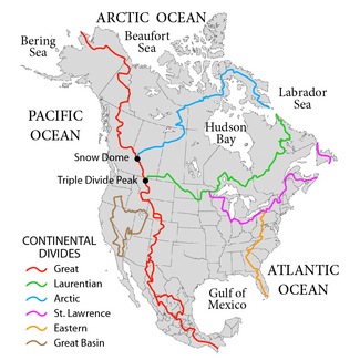
St. Lawrence River Divide
It follows the western boundary of the Saint Louis River watershed, and then winds through the Northern Highland of Wisconsin south of the shore of Lake Superior.
The divide then generally parallels the Portage Escarpment near the southern shore of Lake Erie through eastern Ohio, Pennsylvania, and western New York.
The divides becomes the international border between Maine and Quebec between the headwaters of Halls Stream and the Southwest Branch Saint John River.
The divide then continues into the Notre-Dame Mountains in Quebec, then turns southeasterly through central New Brunswick.
From there, the divide borders the Petitcodiac River basin, crosses through the Isthmus of Chignecto, and runs easterly along the Cobequid Mountains along the northern coast of Nova Scotia and eventually to Cape Canso.