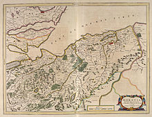
County of Moray
The historic county borders Nairnshire to the west, Inverness-shire to the south, and Banffshire to the east, and has a coast onto the Moray Firth to the north.
The old earldom of Moray was broadly split into the three shires of Elginshire, Nairnshire, and the mainland parts of Inverness-shire.
[4] There was also a short-lived shire centred on Forres, which in the early 14th century was grouped with Nairn, before later being united instead with Elgin.
In 1667 Commissioners of Supply were established for each shire, which would serve as the main administrative body for the area until the creation of county councils in 1890.
Elected county councils were established in 1890 under the Local Government (Scotland) Act 1889, taking most of the functions of the commissioners (which were eventually abolished in 1930).
[13][14] Elginshire County Council held its first meeting on 22 May 1890 at the Old Courthouse (built 1837) which adjoined Elgin Sheriff Court.
[17] The government responded by directing all departments to use Moray, but noted that the legal name would remain Elgin until such time as it could be changed by statute.
[18] The statutory change of name from Elgin to Moray eventually took place in 1947 under the Local Government (Scotland) Act 1947.
[28] Moray consists of a flattish coastal section, containing the main towns, with a hilly interior, extending into the Grampian Mountains in the far south.
The burghs were:[29] Other settlements include: Civil parishes are still used for some statistical purposes, and separate census figures are published for them.
As their areas have been largely unchanged since the 19th century this allows for comparison of population figures over an extended period of time.
The winning design is green, gold and blue, representing the area's agriculture and links to the sea.