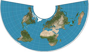
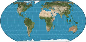
Equal-area projection
In cartography, an equivalent, authalic, or equal-area projection is a map projection that preserves relative area measure between any and all map regions.
Equivalent projections are widely used for thematic maps showing scenario distribution such as population, farmland distribution, forested areas, and so forth, because an equal-area map does not change apparent density of the phenomenon being mapped.
By Gauss's Theorema Egregium, an equal-area projection cannot be conformal.
This implies that an equal-area projection inevitably distorts shapes.
Even though a point or points or a path or paths on a map might have no distortion, the greater the area of the region being mapped, the greater and more obvious the distortion of shapes inevitably becomes.
In order for a map projection of the sphere to be equal-area, its generating formulae must meet this Cauchy-Riemann-like condition:[1] where
For an equal-area map of the ellipsoid, the corresponding differential condition that must be met is:[1] where
The term "statistical grid" refers to a discrete grid (global or local) of an equal-area surface representation, used for data visualization, geocode and statistical spatial analysis.