Esker
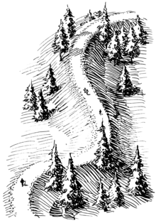
An esker, eskar, eschar, or os, sometimes called an asar, osar, or serpent kame,[1][2] is a long, winding ridge of stratified sand and gravel, examples of which occur in glaciated and formerly glaciated regions of Europe and North America.
After the retaining ice walls melted away, stream deposits remained as long winding ridges.
Eskers form near the terminal zone of glaciers, where the ice is not moving as fast and is relatively thin.
[5] Plastic flow and melting of the basal ice determines the size and shape of the subglacial tunnel.
Less pressure, occurring in areas closer to the glacial maximum, can cause ice to melt over the stream flow and create steep-walled, sharply-arched tunnels.
The sediment generally consists of coarse-grained, water-laid sand and gravel, although gravelly loam may be found where the rock debris is rich in clay.
The village of Kemnay in Aberdeenshire, Scotland has a 5 km (3.1 mi) esker locally called the Kemb Hills.
In Berwickshire in southeast Scotland is Bedshiel Kaims, a 3 km-long (1.9 mi) example which is up to 15 m (49 ft) high and is a legacy of an ice-stream within the Tweed Valley.
[15] Uvayuq or Mount Pelly, in Ovayok Territorial Park, the Kitikmeot Region, Nunavut is an esker.
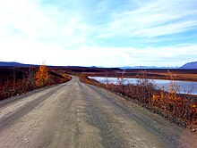
Examples include the Denali Highway in Alaska, the Trans-Taiga Road in Quebec, and the "Airline" segment of Maine State Route 9 between Bangor and Calais.