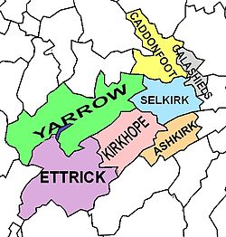
Selkirkshire
In the 1st Century AD Selkirk formed part of the lands of the native people who hunted it rather than settled there.
Neither the Romans, Angles, or the Saxons cleared much of the forestry there and for centuries Selkirk was known for its forest coverage.
During the military occupation of Scotland by Edward I of England, the forest was granted to the Earl of Gloucester.
The origins of the shire are obscure, but sometime around the twelfth century the area of Tweeddale was divided into two sheriffdoms: Peeblesshire to the north and Selkirkshire or Ettrick Forest to the south.
[2] Synton in the parish of Ashkirk, just east of the village centre, was an enclave of Selkirkshire surrounded by Roxburghshire.
[4] His descendant Sir James Murray was deprived of office in 1681 for being remiss in punishing conventicles, but at the Glorious Revolution was raised to the session bench as Lord Philiphaugh and reinstated as sheriff.
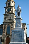
[16] Folk ballads written of the county commemorate the Battle of Philiphaugh in 1645, the 'Dowie Dens' at Yarrow and Tibbie Shiels at St Mary's Loch.
Selkirkshire is a rural county, with a handful of small settlements set within hill and forest country.
The traditional highest point (county top) of Selkirkshire prior to border changes in the 20th century was Dun Rig, with a height of 744 metres (2,441 ft) above sea level.