Fargo-Moorhead Area Diversion Project
[2] Ultimately, it also will free residents and businesses from the need for flood insurance once the project is certified by the Federal Emergency Management Agency (FEMA).
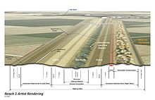
It also incorporates a 22-mile earthen embankment south of the city of Fargo, two first-of-their-kind aqueducts to enable fish passage across the channel, three gated structures to control water flows, and a variety of road and railroad crossings, road grade raises, floodwalls/levees, stormwater lift stations, channel inlets, wetland restoration acreage and mitigation projects[4] The project was authorized for construction by the Water Resources Reform and Development Act of 2014.
[8] It's also the first P3 water management project in North America,[9] and the first green finance initiative in the United States specifically designed for climate change adaptation.
[10] Under the project agreements, the U.S. Army Corps of Engineers is designing and constructing the southern embankment, water control structures and associated infrastructure.
[13] Under the P3 model adopted by the MFDA, the RRVA has taken responsibility for pre-financing the entire portion of its construction work until it is completed and turned over for operation.
The Metro Flood Diversion Authority submitted its Plan B proposal following the work of the Governors' Task Force, which changed the alignment of the embankment and also allowed more water to flow through the Fargo-Moorhead area during project operation.
[19] The FM Area Diversion project is intended to protect the FM-area economy, which generated a Gross Regional Product of $16.8 billion in 2021.
Local sales taxes approved by voters in Fargo and Cass County, N.D., will generate an anticipated $1.2 billion to pay long-term debt service.
The structures have large, radial-arm Tainter gates that will open or close to control floodwater levels during times of extreme flooding.