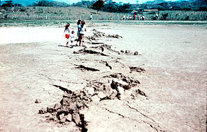
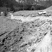
Fault trace
These fault traces are often identified by some kind of linear feature on the surface such as a fence line or small stream that has been offset.
The possibility of life existing on another planet has intrigued many throughout history and identifying features like faults could mean that there are more forces at work than previously thought.
These traces appear as erosion resistant ridges thought to have been formed by water deposited minerals within ancient fault zones.
Finding these fault traces means that there may have been plate tectonics, geothermal interactions, and movement of ground water at some point in the planets history.
[5] Because of the rarity of linear features found in nature, technologies which allow for large scale map view analysis of the earth's surface have been increasingly helpful in revealing fault traces that have otherwise remained unrecognized.
Remote Sensing techniques use imagery acquired by sensors mounted on satellites, aircraft, or even handheld to view different parts of the earth at different scales.
Sudden 90 degree bends or jogs in a stream, or even an extended straight stretch could be possible indicators of a fault trace but when put into larger perspective can be aligned with other pieces of evidence to add confirmation.
There could be a gentle elevation change that don't seem suspicious when walking over it, but when viewed remotely can show that it extends laterally in a straight line and could be evidence of an old fault scarp.