Flood
Surface soil can become saturated, which effectively stops infiltration, where the water table is shallow, such as a floodplain, or from intense rain from one or a series of storms.
Areal flooding begins in flat areas like floodplains and in local depressions not connected to a stream channel, because the velocity of overland flow depends on the surface slope.
When overland flow occurs on tilled fields, it can result in a muddy flood where sediments are picked up by run off and carried as suspended matter or bed load.
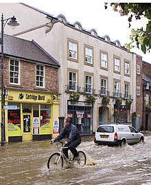
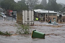
Overland flooding can be devastating because it is unpredictable, it can occur very suddenly with surprising speed, and in such flat land it can run for miles.
The cause may be localized convective precipitation (intense thunderstorms) or sudden release from an upstream impoundment created behind a dam, landslide, or glacier.
In one instance, a flash flood killed eight people enjoying the water on a Sunday afternoon at a popular waterfall in a narrow canyon.
The deadly flood resulted from a thunderstorm over part of the drainage basin, where steep, bare rock slopes are common and the thin soil was already saturated.
As a result, the rising limb of the hydrograph becomes ever quicker as the flood moves downstream, until the flow rate is so great that the depletion by wetting soil becomes insignificant.
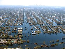
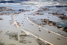
Floods are caused by many factors or a combination of any of these generally prolonged heavy rainfall (locally concentrated or throughout a catchment area), highly accelerated snowmelt, severe winds over water, unusual high tides, tsunamis, or failure of dams, levees, retention ponds, or other structures that retained the water.
Flooding can be exacerbated by increased amounts of impervious surface or by other natural hazards such as wildfires, which reduce the supply of vegetation that can absorb rainfall.
During times of rain, some of the water is retained in ponds or soil, some is absorbed by grass and vegetation, some evaporates, and the rest travels over the land as surface runoff.
[24] Water then runs off the land in quantities that cannot be carried within stream channels or retained in natural ponds, lakes, and human-made reservoirs.
Some precipitation evaporates, some slowly percolates through soil, some may be temporarily sequestered as snow or ice, and some may produce rapid runoff from surfaces including rock, pavement, roofs, and saturated or frozen ground.
Even when rainfall is relatively light, the shorelines of lakes and bays can be flooded by severe winds—such as during hurricanes—that blow water into the shore areas.
Extreme flood events often result from coincidence such as unusually intense, warm rainfall melting heavy snow pack, producing channel obstructions from floating ice, and releasing small impoundments like beaver dams.
[33] Coincident events may cause extensive flooding to be more frequent than anticipated from simplistic statistical prediction models considering only precipitation runoff flowing within unobstructed drainage channels.
[34] Debris modification of channel geometry is common when heavy flows move uprooted woody vegetation and flood-damaged structures and vehicles, including boats and railway equipment.
In the United States, industry experts estimate that wet basements can lower property values by 10–25 percent and are cited among the top reasons for not purchasing a home.
[43] Economic hardship due to a temporary decline in tourism, rebuilding costs, or food shortages leading to price increases is a common after-effect of severe flooding.
Damage to roads and transport infrastructure may make it difficult to mobilize aid to those affected or to provide emergency health treatment.
Flooding can cause chronically wet houses, leading to the growth of indoor mold and resulting in adverse health effects, particularly respiratory symptoms.
Research suggests that there will be an increase of 30–50% in adverse respiratory health outcomes caused by dampness and mold exposure for those living in coastal and wetland areas.
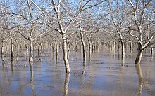
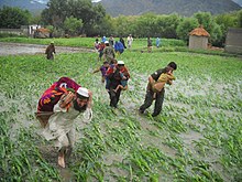
For some fish species, an inundated floodplain may form a highly suitable location for spawning with few predators and enhanced levels of nutrients or food.
However, it is best practice within landscape engineering to rely more on soft infrastructure and natural systems, such as marshes and flood plains, for handling the increase in water.
In the riparian zone near rivers and streams, erosion control measures can be taken to try to slow down or reverse the natural forces that cause many waterways to meander over long periods of time.
In areas prone to urban flooding, one solution is the repair and expansion of human-made sewer systems and stormwater infrastructure.
[56]: 22–23 Critical community-safety facilities, such as hospitals, emergency-operations centers, and police, fire, and rescue services, should be built in areas least at risk of flooding.
[57][page needed] In the United States, the Association of State Floodplain Managers works to promote education, policies, and activities that mitigate current and future losses, costs, and human suffering caused by flooding and to protect the natural and beneficial functions of floodplains – all without causing adverse impacts.
In planning for and reacting to flood disasters, managers provide workers with hard hats, goggles, heavy work gloves, life jackets, and watertight boots with steel toes and insoles.
In order to make the most accurate flood forecasts for waterways, it is best to have a long time-series of historical data that relates stream flows to measured past rainfall events.