Quadripoint
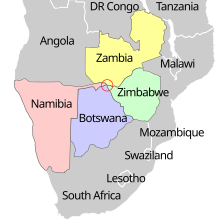
Some older sources claimed that a quadripoint existed in Africa,[12] where the borders of Namibia, Botswana, Zambia, and Zimbabwe come together at the confluence of the Cuando (also called Chobe) and Zambezi rivers.
[13][14][15] In the absence of legal clarity, it is now widely believed that instead, two separate tripoints exist about 100 to 150 metres (330–490 ft) apart[citation needed] (but see below regarding due diligence preceding bridge construction).
Seeking a more efficient route between these two colonies via the Zambezi River, Germany signed the Heligoland–Zanzibar Treaty with Britain in 1890, thereby gaining control of a narrow salient called the Caprivi Strip.
[17] The existence of a short boundary of about 150 metres (490 ft) between Zambia and Botswana was agreed by all four states[citation needed] in the 2006–10 period, and is shown in the African Development Fund project map.
[19] Moreover, it was reported in 2014 that Namibia actually granted Botswana and Zambia an easement to build their bridge across what all three parties concurred was Namibian territory.
[21] A true four-country point did formerly exist in Africa for a period of eight months during 1960 and 1961, in southern Lake Chad, at the location of the present Cameroon–Chad–Nigeria tripoint.
[22][23] The international boundary touches (or crosses) itself, without imparting political subdivision, within the commingled municipalities of Baarle-Nassau (North Brabant, Netherlands) and Baarle-Hertog (Antwerp, Belgium).
The peculiar situation, which occurs at Baarle but once (at the touchpoint of Belgian enclaves H1 and H2),[24] has existed at least cadastrally since about 1198, but its current international distinction dates only from 1830.
However, the northernmost point of the Manitoba–Saskatchewan border as surveyed is slightly off from 60° north 102° west, therefore the laws were not perfectly clear about whether the Nunavut–NWT boundary, was to meet the others in a quadripoint or not.
4) and British Columbia (Regional District of East Kootenay) with the Montana counties of Flathead and Glacier where the 49th parallel crosses the Continental Divide also unites an international peace park comprising national parks of both countries (Waterton Lakes in Canada and Glacier in the United States).
It has been a politically important and precisely stipulated international boundary point since 1818; has been monumented since 1876 (now by a hollow metallic obeliskoid marker numbered 272); and has maintained a quadripartite status since 1893.
[33][34][35][36] The other of the pair occurs in the international boundary sector known as the Highlands, on the ridge separating the Gulf of Saint Lawrence watershed from the Gulf of Maine watershed, where three minor civil divisions of the state of Maine—namely Dennistown, Forsyth, and Sandy Bay Townships, all in Somerset County—meet Le Granit Regional County Municipality of the province of Quebec.
This quadripoint, which was legally delimited in 1873 and validated in 1895, is marked (like all the corners of the minor civil divisions of Maine) by a brightly painted 8-foot wooden pole.
[37][38][39][40] There is a subnational quadripoint in Colombia at approximate coordinates 4°44′07″N 73°03′04″W / 4.73528°N 73.05111°W / 4.73528; -73.05111, at the confluence of the Upía and Guavio rivers, where the borders of the Boyacá, Casanare, Meta, and Cundinamarca departments come together.
The municipalities of Vrbanja, Drenovci, Bošnjaci and Nijemci in Vukovar-Srijem County meet at a quadripoint just south of the A3 motorway, near Spačva.
The municipalities of Krapina, Mihovljan, Bedekovčina and Sveti Križ Začretje in Krapina-Zagorje County meet at a quadripoint just north of the village of Komor Začretski.
The municipalities of Čakovec, Sveti Juraj na Bregu, Selnica and Mursko Središće in Međimurje County share a quadripoint north of the village of Žiškovec.
At a delimitation point determined partly following World War I and partly following World War II, and indirectly monumented by international pillars 415 and 420 on respective riverbanks, there is on the thalweg (center of downstream navigation channel) of the Danube a trinational quadripoint, where the Hungarian counties of Baranya and Bács-Kiskun meet the Croatian county of Osječko-Baranjska and the Serbian (Vojvodina) District of West Bačka (although Croatia continues to claim its former Yugoslav cadastral territory east of the Danube, leaving the quadripoint technically unsettled).
[citation needed] Four regions of Mauritania, namely Adrar, Brakna, Tagant, and Trarza, meet at a quadripoint formed by an intersection of non-cardinally oriented geodesic lines that define their borders.
[50][51] At a secondary summit of Pilsko Peak called Góra Pięciu Kopców, where there is situated a prominent turnpoint on the border of Poland and Slovakia that is evidently demarcated by a primary border marker numbered III/109, there lies a binational quadripoint at which the rural gmina or municipality of Jeleśnia in Żywiec County of the Silesian Voivodeship of Poland apparently meets three municipalities of Námestovo District of Žilina Region of Slovakia called, respectively, Mutne, Oravské Veselé, and Námestovo (although it is unclear if the last-mentioned is an outlier of the eponymous district seat or just an unorganized territory of the Námestovo District itself).
The village of Four Marks in Hampshire is so named, because historically four adjoining tithings (or parishes) of Medstead, Ropley, Faringdon, and Chawton met there in a quadripoint.
Similarly, the Four Shire Stone that sits a mile and a half east of Moreton-in-Marsh used to mark the location where the counties of Warwickshire, Oxfordshire, Gloucestershire, and Worcestershire all met before borders were redrawn in 1931.
[56][57] Another occurrence—actually a pair of such quadripoints linked to an unclaimed area—is inferred where the southern end of the Alaska sector of the Canada–United States border aberrates into two crisscrossing versions or claim lines.
[55] The summit of Risnjak mountain in Primorje-Gorski Kotar County in Croatia is a meeting point of five municipalities: Čabar, Delnice, Lokve, Bakar and Čavle.
[62][63][64] The townlands are, clockwise from north, Broom-More, Tavnaghboy, Kilrobert, Clare Mountain, Aghaleck, Corvally, Essan, Cleggan, Stroan, and Tullaghore.
These municipalities are Adrano, Biancavilla, Belpasso, Bronte, Castiglione di Sicilia, Maletto, Nicolosi, Randazzo, Sant'Alfio, and Zafferana Etnea.
The territory of Bronte touches the summit of Mount Etna from two sides, making this multipoint one of elevenfold complexity[clarification needed].