Funnel cloud
If strong cyclonic winds are occurring at the surface and are connected to a cloud base, regardless of condensation, then the feature is a tornado.
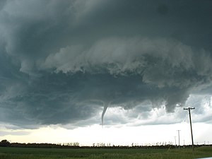
The surface level vortex tends to strengthen over time following initial formation, making the debris swirls and the condensation more apparent.
Although cold-air funnels rarely make ground contact, surface level vortices sometimes become strong enough for condensation cloud to "touch down" briefly, becoming visible as weak tornadoes or waterspouts.
The funnels develop where atmospheric instability and moisture are sufficient to support towering cumulus clouds but typically limited to no or to little precipitation.
The mixing of cooler air in the lower troposphere with air flowing in a different direction in the middle troposphere causes the rotation on a horizontal axis, which, when deflected and tightened vertically by convective updrafts, forms a vertical rotation that can cause condensation to form a funnel cloud.
[9] Cold-air funnel clouds are a common sight along the Pacific Coast of the United States, particularly in the spring or fall.
No advance weather watches or warnings were issued by Environment Canada, and the tornado was spawned from one of the few non-severe storm clouds moving through the area.