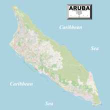
Geography of Aruba
The geography of Aruba, located at the juncture of the South American and Caribbean tectonic plates, has been shaped by a complex interplay of geological processes.
This region is characterized by a complex fault system where the Caribbean Plate moves westward in relation to South America.
This region developed in the outcrop area of the metamorphosed volcanic rocks of the Aruba Lava Formation (ALF), and it features east-to-west running valleys controlled by faults.
[2] The arid landscape in Aruba is not solely a product of its climate but is also a consequence of extensive deforestation and exploitation during the Spanish colonization of the island.
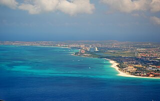
In stark contrast to the southern shores, Aruba's northern sea is typically characterized by rough waters with a deep blue hue, rocky terrain and consists mostly of wave-cut coral limestone terraces interspersed with small sandy coves referred to as boca in Papiamento, which translates to "mouth" in English.
[10] The distinctive appearance of the wave-cut terraces is influenced by the islands' location within the arid region along the southern Caribbean coastline.
[10] Aruba has a barrier reef, it generally lies about 400 yards (370 m) offshore and extends along the southwest coast between Punta Brabo and Oranjestad.
[10] The oldest geological unit visible on Aruba is the ALF, which comprises volcanic and volcaniclastic rocks of basaltic composition, with a thickness exceeding 3,000 metres (9,800 ft).
In contrast, the middle terrace, located at 15–25 metres (49–82 ft), dates back up to 510 Kyr, indicating a slow (0.05 mm/yr) rate of tectonic uplift of Aruba.
However, Aruba later subsided beneath the sea level in the middle Miocene, as documented by the emergence of widespread elevated coastal limestone terraces.
Introduced in the early 16th century, feral goats (Capra hircus) and donkeys pose a significant threat to Aruba's environments, causing both direct and indirect harm due to excessive grazing.
[23] The Cane toad, also called Sapo locally,[24] is an invasive species with a detrimental impact on Aruba's fauna, such as the Dori (Pleurodema brachyops).
[25][26] Toads favor damp environments, including (irrigated) gardens of residential homes and tourist accommodations, such as hotels and resorts.
Aruba has a recorded history of 10 previous introduction of non-native reptiles species, including two anoles, Anolis sagrei and A. porcatus, and four geckos, Gonatodes albogularis, G. antilensis, G. vittatus, and Hemidactylus mabouia.
[28] Aruba features a hot semi-arid climate (Köppen BSh) characterized by consistently warm temperatures throughout the year.
The origins of over-tourism can be traced back to the 1970s and 1980s when people first expressed concerns about the possible negative effects on society and the environment due to uncontrolled tourism growth.
Their involvement in disseminating misleading information about the environmental repercussions of an upcoming hotel project near Baby Beach has come under question.
[35][36][37] The chemical Oxybenzone in sunscreen products is banned due to its harmful effects on marine life and coral reefs when it enters the ocean.
While it helps protect the skin from UV rays, it also causes severe damage to corals and can lead to hormonal imbalances.
The law's main objective is to prevent further damage to nature and the environment, promoting a healthier quality of life without single-use plastics and Oxybenzone-containing products.
They stabilize beaches, provide shelter for creatures like hermit crabs, offer hiding places for small fish, and serve as nesting material for shorebirds.
[41] Aruba's infrastructure, including the tourism sector, was developed without considering the potential impacts of light pollution on the ecological environment and human experiences.
[43] All sea turtles species are endangered,[44] including Leatherback, Loggerhead, Green and the Hawksbill, which are nocturnal wild life on Aruba.
Artificial lighting can deter adult females from nesting or disorient emerging hatchlings, causing them to venture inland where they risk dehydration or harm.
Over the past decade, the closure of the San Nicolas refinery has enabled the recovery of flora and fauna, while reducing light pollution, making the night sky brighter.
However, the preservation of ecosystems faces increasing challenges with the expansion of the tourism zone and the construction of a new hotel in the southeast part of the island, Seroe Colorado.
Among Aruba's 8 regions, 5 have over 50% of the population using only Papiamento at home, with Oranjestad East having the highest percentage at 56.6%, and San Nicolas South the lowest at 23.4%.
In the regions Noord/Tanki Leendert and Oranjestad East, one in four persons speaks Papiamento and Spanish in the household, while San Nicolas North has the lowest percentage at 8.9%.
However, in the last decade, the construction of condominiums, guesthouses, and rental apartments has increased by 51%, adding to existing infrastructural pressures and coastal resort density levels.
[30] Locals are concerned about the impact of the growing number of tourism-focused properties and accommodations on Aruba's fragile infrastructure and ecological environment.