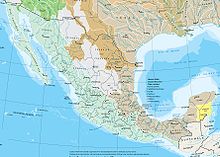
Geography of Mexico
The meandering Río Bravo del Norte (known as the Rio Grande in the United States) defines the border from Ciudad Juárez east to the Gulf of Mexico.
The landmass of Mexico dramatically narrows as it moves in a southeasterly direction from the United States border and then abruptly curves northward before ending in the 500-kilometer-long Yucatán Peninsula.
The Sierra Madre Oriental mountain range starts at the Big Bend region of the border with the U.S. state of Texas and continues 1,350 kilometres (840 mi) until reaching Cofre de Perote, one of the major peaks of the Cordillera Neovolcánica.
The Mexican Altiplano, stretching from the United States border to the Cordillera Neovolcánica, occupies the vast expanse of land between the eastern and western sierra madres.
The northern altiplano averages 1,100 meters in elevation and continues south from the Río Bravo del Norte through the states of Zacatecas and San Luis Potosí.
The Cordillera Neovolcánica begins at the Río Grande de Santiago and continues south to Colima, where it turns east along the nineteenth parallel to the central portion of the state of Veracruz.
This range contains three peaks exceeding 5,000 metres (16,000 ft): Pico de Orizaba (Citlaltépetl)—the third highest mountain in North America—and Popocatépetl and Iztaccíhuatl near Mexico City.
The Sierra Madre del Sur extends 1,200 kilometers along Mexico's southern coast from the southwestern part of the Cordillera Neovolcánica to the nearly flat isthmus of Tehuantepec.
In 2024, a team of oceanographers discovered the world's deepest blue hole, Taam Ja, meaning 'deep waters' in Mayan, in Chetumal Bay, Mexico.
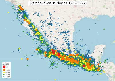
In September 1985, an earthquake measuring 8.0 on the moment magnitude scale and centered in the subduction zone off Acapulco killed more than 4,000 people in Mexico City, more than 300 kilometers away.
Areas south of the twentieth-fourth parallel with elevations up to 1,000 meters (3,281 ft) (the southern parts of both coastal plains as well as the Yucatán Peninsula), have a yearly median temperature between 24 and 28 °C (75.2 and 82.4 °F).
Although low-lying areas north of the twentieth-fourth parallel are hot and humid during the summer, they generally have lower yearly temperature averages (from 20 to 24 °C or 68.0 to 75.2 °F) because of more moderate conditions during the winter.
Towns and cities at this elevation south of the twenty-fourth parallel have relatively constant, pleasant temperatures throughout the year, whereas more northerly locations experience sizeable seasonal variations.
Average rainfall totals are between 600 and 1,000 millimeters (23.6 and 39.4 in) in most of the major populated areas of the southern altiplano, including Mexico City and Guadalajara.
Several hurricanes per year strike the Caribbean and Gulf of Mexico coastline, however, and these storms bring high winds, heavy rain, extensive damage, and occasional loss of life.
Hurricane Gilbert passed directly over Cancún in September 1988, with winds in excess of 200 kilometers per hour (124 mph), producing major damage to hotels in the resort area.
It then struck northeast Mexico, where flooding from the heavy rain killed dozens in the Monterrey area and caused extensive damage to livestock and vegetable crops.
Already climate change has impacted agriculture,[10] biodiversity, farmer livelihoods, and migration,[11][12] as well as water, health, air pollution, traffic disruption from floods, and housing vulnerability to landslides.
Vast expanses of southern and southeastern tropical forests have been denuded due to mineral resource extraction,[16][17] and then, far behind in second place, for cattle-raising and agriculture.
Fragile because of its semiarid and arid character, the soil of the region has become increasingly damaged through excessive cattle-raising and irrigation with waters containing high levels of salinity.
For example, inadequately regulated petroleum exploitation in the Coatzacoalcos-Minatitlán zone in the Gulf of Mexico has caused serious damage to the waters and fisheries of Río Coatzacoalcos.
More than 1,000 barrels (160 m3) of gasoline seeped from a corroded Mexican Petroleum (Petróleos Mexicanos—Pemex) pipeline into the municipal sewer system, where it combined with gases and industrial residuals to produce a massive explosion that killed 190 persons and injured nearly 1,500 others.
[20] Sánchez-Medina finds some change toward environmentally benign practices still occurs but is voluntary and has motives other than financial reward or fear of enforcement.
Mexico City sits in a valley surrounded on three sides by mountains, which serve to trap contaminants produced by the metropolitan area's 15 million residents.
One government study in the late 1980s determined that nearly 5 million tons of contaminants were emitted annually in the atmosphere, a tenfold increase over the previous decade.
Carbons and hydrocarbons from the region's more than 3 million vehicles account for approximately 80% of these contaminants, with another 15%, primarily of sulfur and nitrogen, coming from industrial plants.
One study of twelve urban areas worldwide in the mid-1980s concluded that the residents of Mexico City had the highest levels of lead and cadmium in their blood.
Under the program, metropolitan area residents were prohibited from driving their vehicles one day each work week based on the last number of their license plate.
Thermal inversions reached such dangerous levels at various times in the mid-1990s that the government declared pollution emergencies, necessitating sharp temporary cutbacks in vehicle use and industrial production.
5,426 m) poses a threat to Mexico City; other historically active volcanoes include Barcena, Ceboruco, El Chichon, Michoacan-Guanajuato, Pico de Orizaba, San Martin, Socorro, and Tacana Environment – current issues: Natural fresh water resources scarce and polluted in north, inaccessible and poor quality in center and extreme southeast; raw sewage and industrial effluents polluting rivers in urban areas; deforestation; widespread erosion; desertification; serious air pollution in the national capital and urban centers along the US-Mexico border; land subsidence in Valley of Mexico caused by groundwater depletion.