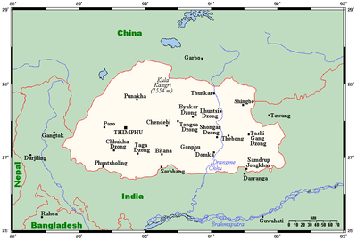
Geography of Bhutan
It is fairly evenly sandwiched between the sovereign territory of two nations: first, the People's Republic of China (PRC) on the north and northwest.
The second nation is the Republic of India on the south, southwest, and east; there are approximately 659 kilometres (409 mi) with the states of Arunachal Pradesh, Assam, West Bengal, and Sikkim, in clockwise order from the kingdom.
Bhutan's territory used to extend south into present-day Assam, including the protectorate of Cooch Behar, but, starting from 1772, the British East India Company (EIC) began to push back the borders through a number of wars and treaties, severely reducing Bhutan's size until the Treaty of Sinchula of 1865, when some border land was ceded back.
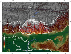
Below the rock and ice of the highest peaks lies an extensive arc of Eastern Himalayan alpine shrub and meadows, which contain, in additions to grasslands, a wide variety of rhododendrons and herbaceous plants.
The region is characterised by its many rivers (flowing into India's Brahmaputra), its isolated valleys that house most of the population, and the expansive forests that cover seventy per cent of the nation.
The Lateral Road from Thimphu to Punakha crosses the Dochu La (3,116 metres (10,223 ft)), which features 108 chortens built to commemorate the expulsion of Assamese guerrillas.
The extreme southern strip of the nation consists mostly of Himalayan subtropical broadleaf forests that grade into the tropical plains of the Terai-Duar savanna and grasslands, more typical of India.
Centuries of isolationism, a small population, and topographical extremes have led to Bhutan maintaining one of the most intact ecosystems in the world.
This stems from two things: the fact that after the British granted sovereignty to their South Asian possessions, Bhutan, a protectorate, was never put under the administration of India, except for its Foreign Relation Policies under the Indo-Bhutan Treaty of 1949.
The Indian Army patrols Bhutan's frontiers and has played a major role in the development of the country's road infrastructure.
The second reason comes from the aggression against Tibet by China from 1949 to 1959; the Tibetans have strong cultural, historical, and religious connections to Bhutan.
The heartland of Bhutan has never been successfully invaded; the British, while establishing a protectorate over the nation, did so with threats to the low-lying territories below the highlands.
Temperatures in Thimphu, located at 2,200 metres (7,218 ft) above sea level in west-central Bhutan, range from approximately 15 to 26 °C (59.0 to 78.8 °F) during the monsoon season of June through September but drop to between about −4 and 16 °C (24.8 and 60.8 °F) in January.
The monsoon weather, blocked from its northward progress by the Himalayas, brings heavy rains, high humidity, flash floods and landslides, and numerous misty, overcast days.
From late November until March, winter sets in, with frost throughout much of the country and snowfall common above elevations of 3,000 metres (9,843 ft).
A 2008 United Nations report suggested that due to rising temperatures, glaciers in Bhutan were retreating at a rate of 30–40 metres (100–130 ft) per year, poised to make many lakes burst their banks and send millions of gallons of floodwater downstream.
[6] Similarly, the member nations of South Asian Association for Regional Cooperation (SAARC) adopted bilateral agreements including measures on climate change and glaciers at its summit in April 2010.
These branches form the Drangme Chhu basin, which spreads over most of eastern Bhutan and drains the Tongsa and Bumthang valleys.
[15][16][17][18][19][20]: 72, 84, 91 Despite modernization and development of transport in Bhutan, including a national highway system, travel from one valley to the next remains difficult.