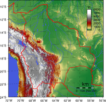
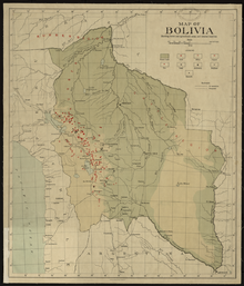
Geography of Bolivia
To the east of that mountain chain are lowland plains of the Amazon Basin, and to the west is the Altiplano which is a highland plateau where Lake Titicaca is located.
In western Bolivia, the Cordillera Occidental is a chain of dormant volcanoes and solfataras, volcanic vents emitting sulfurous gases.
Along the Altiplano's eastern side is a continuous flat area, which has served as Bolivia's principal north–south transport corridor since colonial times.
The entire Altiplano was originally a deep rift between the cordilleras that gradually filled with highly porous sedimentary debris washed down from the peaks.
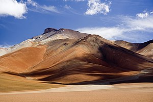
Rainfall in the Altiplano decreases towards the south, and the scrub vegetation grows more sparse, eventually giving way to barren rocks and dry red clay.
Near the Argentine border, the floor of the Altiplano rises again, creating hills and volcanoes that span the gap between the eastern and western cordilleras of the Andes.
[1] The northeastern flank of the Cordillera Real is known as the Yungas, from the Aymara and Quechua word yunka meaning "warm valley".
[2][3] The steep, almost inaccessible slopes and peaks of this mainly semitropical valley area northeast of La Paz offer some of the most spectacular scenery in Bolivia.
The valley floors range from 2,000 to 3,000 metres above sea level, and this lower elevation means milder temperatures than those of the Altiplano.
Although comprising over two-thirds of the national territory, the region is sparsely populated and, until recently, has played a minor role in the economy.
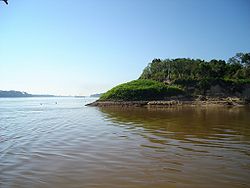
Because much of the topsoil is underlain by claypan, drainage is poor, and heavy rainfall periodically converts vast parts of the region to swamp.
The central area, comprising the northern half of Santa Cruz Department, has gently rolling hills and a drier climate than the north.
Santa Cruz, the largest city in the lowlands, is located here, as are most of Bolivia's petroleum and natural gas reserves.
The extreme variation in rainfall supports only thorny scrub vegetation and cattle grazing, although recent discoveries of natural gas and petroleum near the foothills of the Andes have attracted some settlers to the region.
[5] arable land: 3.97% permanent crops: 0.20% other: 95.83% (2012) Irrigated land: 1,282 km2 (2003) Total renewable water resources: 622.5 cu km (2011) Freshwater withdrawal (domestic/industrial/agricultural: total: 2.64 km3/yr (25%/14%/61%) per capita: 305.8 m3/yr (2005) Natural hazards: flooding in the northeast (March–April) Environment – current issues: the clearing of land for agricultural purposes and the international demand for tropical timber are contributing to deforestation; soil erosion from overgrazing and poor cultivation methods (including slash-and-burn agriculture); desertification; loss of biodiversity; industrial pollution of water supplies used for drinking and irrigation Environment – international agreements: party to: Biodiversity, Climate Change, Climate Change-Kyoto Protocol, Desertification, Endangered Species, Hazardous Wastes, Law of the Sea, Marine Dumping, Nuclear Test Ban, Ozone Layer Protection, Ship Pollution, Tropical Timber 83, Tropical Timber 94, Wetlands signed, but not ratified: Environmental Modification, Marine Life Conservation Geography – note: landlocked; separated from the Pacific Ocean via Chile.
[19] Scientists began alerting the Bolivian government to the problem of melting glaciers in the 1990s, but it was not until 2012 that the authorities responded with real protection policies.
A Project for Adaptation to the Impact of Accelerated Glacier Recession in the Tropical Andes (PRAA) was then set up, with the mission to "strengthen the monitoring network" and "generate information useful for decision-making."
Authorities have also developed programs to educate the population about the consequences of global warming to push back on certain harmful agricultural practices.